See on Scoop.it – Global Health Care
Using GIS to Improve Health Resource Allocation in Yemen
A very basic Step-by-Step example of how to strategize healthcare . . .
Research question for this study:
What are the gaps in availability and accessibility of immunization services in Amran Governorate, Yemen?
Results:
This is an example of a health GIS sample analysis was used to identify gaps in immunization services in Amran Governorate.
The value of the map in strategizing healthcare is in enables you to more precisely target manpower, intervention activities and expenses.
The maps for this project were generated using ESRI’s ArcGIS, but many of these same tasks can be done using other open access GIS tools out there. Buffer and flow or travel analysis is possible in some of the freeware or shareware packages. The hardest step to locate a tool for is the unique Theissen Polygon process (show in step 2, highlighted in step 4).
These planners utilized a World Health Organization packet made available known as Yemen Health Analyzer ArcView GIS Tool, or Health Analyzer, which works as an extension to ArcGIS. It is available for download at http://www.healthsystems2020.org/content/resource/detail/2142/.
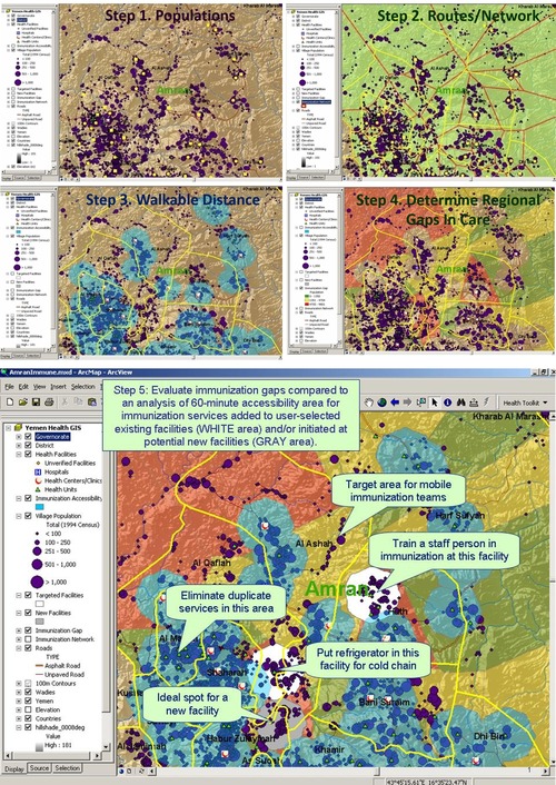
Descriptions accompanying the above set of maps:
Step 1: Plot population areas by size (PURPLE points) and identify health facilities with immunization services and vaccine refrigerator using the Facility Survey Analyzer (YELLOW points).
Step 2: Analyze the immunization services network by dividing area according to closest proximity to service provider (LT GREEN area) using Service Network Provider tool.
Step 3: Analyze 60-min walking accessibility/coverage area (BLUE) using the Facility Accessibility Mapper.
Step 4: Analyze population-weighted gaps in immunization coverage and target prioritized areas or health facilities for intervention (RED vs. YELLOW or GREEN areas) using the Healthcare Gap Analyzer.
Step 5: Evaluate immunization gaps compared to an analysis of 60-min accessibility area for immunization services added to user-selected existing facilities (WHITE area) and/or initiated at potential new facilities (GRAY area).
For more on the Yemen Health Analyzer ArcView GIS tool, you can email — info@healthsystems2020.org.
This information is from: http://www.healthsystems2020.org/section/where_we_work/yemen/gis
See on www.healthsystems2020.org
