See on Scoop.it – Episurveillance
Faculty Project: 2013-2014
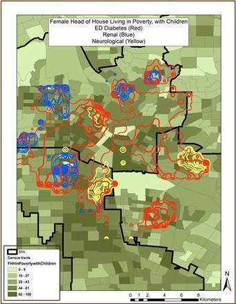
PI: Andrew Curtis
Collaborators: Wei-An Andy Lee, Kreck Medical Center of the University of Southern California
Abstract
This project is designed to understand the diabetes landscape of vulnerable populations in the Boyle Heights area of Los Angeles and to help facilitate intervention and management strategies for a participating diabetes clinic. The objective of this work is to develop a geospatial tool and/or approach that is easy to implement and is transferable amongst other resource challenged clinics serving vulnerable populations. To achieve this, the GIS Health & Hazards Lab is currently (1) Providing a comprehensive summary review of health, social science and planning research previously conducted in Los Angeles, (2) Evaluating the feasibility of using spatial analysis of health and census data for the targeted neighborhood of Boyle Heights, and (3) Piloting the use of mobile mapping to capture the fine scale built environment of patients in Boyle Heights.
See on www.kent.edu
