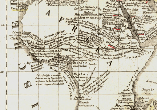
A section of the first disease map of the world. From Friedrich Schnurrer’s ‘Charte über die geographische Ausbreitung der Krankheiten: vorgelegt der Versammlung Deutscher Aerzte und Naturforscher zu München’, Published 1827.
In 1827, Friedrich Schnurrer’s ‘Charte Uber die geographische Ausbreitung der Krankheiten’ was published detailing his summary of diseases around the world. Schnurrer wasn’t the first to study disease patterns globally, he was simply the first to place all of his notes on the world diseases and epidemics he know and read about onto a single map.
One of the earliest essays on disease and place, in terms of the planet, was the work of Johanne Christophor Homann, with his Medicinae Cum Geosophia Nexu [the Medical-Geography Connection], 1720. (see my page – http://wp.me/Puh6r-7MS 😉
The next massive tome published on disease patterns was by the famous author and printer of a very young United States, Noah Webster, who wrote a compendium on the history of the outbreaks around the world, all in an attempt to define geographic and climatic reasons for their recurrences (link below). His book served to explain how and why the United States was experiencing numerous, deadly yellow fever epidemics, which were referred to as the "black plague" at the turn of the century. Webster’s have a natural explanation for all of these events ensuing around the world, blaming the diseases on volcanoes, massive storm patterns, earthquakes, increased global heating by the sun, and yes, environmental and climate change (for a review of Webster’s theory of weather change patterns, deforestation, and climate change, see: Deforestation and Global Cooling: A New Theory for Disease by Noah Webster, 1810, at http://wp.me/Puh6r-3JA (2012); and http://www.smithsonianmag.com/ist/?next=/history/americas-first-great-global-warming-debate-31911494/ (2011)).
in 1813, Schnurrer wrote ‘Geographische Nosologie oder di lehre von den Veränderungen der Krankheiten’ , that is to say, with brevity, knowing the geography of certain disease types.
which set the stage for his next important publication, the map of world diseases published in the 1828 Das Auslan (full citation with link to scanned copy at the end).
My purpose for reviewing this map and Schnurrer’s earlier work was to determine if there was any evidence for Ebola found on the map, and/or in the earlier writings by Schnurrer on the global disease patterns documented in explorers’, settlers’ and travelers’ writings.
The way Schnurrer and others for the time defined disease patterns was by their place of natural existence, known as the nest or nidus for a disease, and by their placement on the earth in relation to its latitudinal patterns, used to describe airflow and climate, the weather associated with the disease patterns documented for the time, and the local topography and natural ecological settings that the authors linked to these disease pattern observations.
Only the map will be reviewed for the moment.
The current behavior of Ebola shows that it is staying north of the equatorial line. If we review the diseases of this region, we find thirty nine distinct disease descriptions given for illnesses common to Africa between 0 and 30 degrees north. That part of African between the 0 and 20 degrees latitude line is for the most part equatorial in nature. Two attacks of "pestilence" are noted in this "torrid" or tropical zone (as later medical geographers referred to it), one epidemic each for the years 1696 and 1811. Since both of these are along the eastern end of upper Africa, they are rule out as Ebola possible ebola events for now, even without reviewing their symptomatology .
Throughout the north torrid region, there are numerous disease types defined symptomatically by Schnurrer as fevers, bearing the word fiber in their categorical name assignments ("Fieber", abbrev. as "Fieb.", "f" or "F."). The Pox is also noted ("Poken", with a brief reference to the "Quarantaine" performed). Numerous forms of venereal disease are displayed (abbrev. "v.d." or identified by their namesakes–syphilis and gonorrhea).
To differentiate the large number of fevers that appear on this map, the related symptoms noted are helpful. Galliche Fieber is yellow fever, that by Senegal is "common to the Negroes. . . ). Galliche rem[ittent] fever is possibly yellow fever, but also possibly malaria (remittence refers to cycling). A number of intestinal worm or "animalcule" diseases are also worth noting ("Faden ~~").
Just south of the equator is Gangran des Mastdarms nach heftigen Kopf u. lenden schmerzen Berriberri (Zuchelli). It is displayed along and south of the Congo River. From its name we know that it could be called the "Gangrene de Mastarms", a necrosis or gangrene of the entire intestinal tract commonly linked to some form of diphtheria by the late 1800s (see Semple, 1879). The descriptive portion of this disease name is "hestigen Kopf u Lenden schmerzen Berriberri", which translates to "vehement head & lumbar pain beriberi", the last section implying an appearance of beriberi–appearing cyanotic and about to die. (see http://renovatingyourmind.com/2013/03/25/renovating-your-minds-makes-a-social-call-to-the-first-member-of-the-b-complex-family-b1-thiamine/beriberi-alcoholism-thiamine1-deficiency/ 😉
This is possibly the first documentation of Ebola as a disease native to the Congo River on a map, by Missionary Father Antonio Zuchella in 1696 (Benicken, 1824), in what it now the DR Congo.
*******************************************************
REFERENCES (if not in the above text).
A BRIEF HISTORY OF EPIDEMIC AND PESTILENTIAL DISEASES ; WITH THE PRINCIPAL PHENOMENA OF THE PHYSICAL WORLD, WHICH PRECEDE AND ACCOMPANY THEM, AND OBSERVATIONS DEDUCED FROM THE FACTS STATED. IN TWO VOLUMES. BY NOAH WEBSTER,
At http://english.byu.edu/facultysyllabi/KLawrence/WEBSTER.briefhistory.pdf
Geographische Nosologie oder die Lehre von den Veränderungen der Krankheiten … 1813. By Friedrich Schnurrer. http://books.google.com/books?id=W84UWCIi3qMC
1824. Das Auslan. Ein Tagblatt fur Kunde des geistigen und sittlichen Lebens der Volker mit besonderer Rucksicht auf verwandte Erscheinungen in Deutschland. Erster Jahrgang. Bd. 1-2. Munchen der Literarisch-Artistischen Anstalt der J. G. Cotta’schen Buchhandlung. 1828 / /
Der Verleger Johann Friedrich Cotta …, Volume 1, Issues 1787-1814,
edited by Deutsches Literaturarchiv / /
Nr. 90, volume 30. 22 Sept 1827, S. 357-359. Die geographische Vertheilung der Krankheiten, vorgelsesen in der Versammlung Deutscher Aertze und naturfirscher zu Munschen den 22 Sept 1827 (S. 3570359). Charte uber die Georgraphische Ausbreitung der Krankheiten von Frid. Schnirrer Med. Doc. Vorgelegt der Versammlung Deutscher und Naturfischer zu Munchen den 22 September 27. Lithographie. 1 gefalt. Bl. 2).
Title: Charte über die geographische Ausbreitung der Krankheiten: vorgelegt der Versammlung Deutscher Aerzte und Naturforscher zu München
The map is available for viewing and download at:
http://archive.thulb.uni-jena.de/hisbest/receive/HisBest_cbu_00025637
Robert Hunter Semple. 1879. On diphtheria
http://books.google.com/books?id=5RkDAAAAQAAJ&pg=PA59
Zeitrechnungs-Tafeln für den historischen Handatlas: Mit steter Rücksicht …
By Friedrich Wilhelm Benicken . 1824.
http://books.google.com/books?id=P7lRAAAAcAAJ&pg=PA135
Reference noted in the book (sic): "Deo Pater-Merolla Reife nach Congo. 1696. Der Miffionar Ant. Zuchelli bereifet Congo. – Die Portugifen werden vom Kuatenhandel verbrängt, behalten jedoeh Mazagan und die vier Guinea-Infeln."
See on Scoop.it – Medical GIS Guide
