The patterns are in general for Ebola spread somewhat predictable.
When viewed in a global sense, we get a better perspective as to why foreign born diseases inevitably go northward as the season progresses.
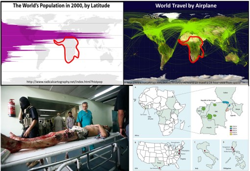
Population density and clustering in relation to the latitude is the reason diseases diffuse from the tropics to the northern temperate zones where more people reside. Any one looking at the above map with population density displayed relative to latitude can figure this out.
But the above basic display of latitude and people relationship took centuries to develop, still longer to make sense in terms of diffusion processes and the importance of spatial epidemiological research.
Source: news.yahoo.com
Today’s vision of how a disease spreads was not to obvious to people during the 17th and 18th centuries. Through observations made over time and distance, doctors and scientists developed what they referred to as "The Latitude of Pestilence Law" in 1814. This law explained epidemics and the migration of diseases as a consequence of global climate differences across the earth’s surface and as a consequence of seasonal changes making of section of the earth resemble another climatologically, and in particular in terms of amounts of rain, daily temperature levels, humidity, and the health attached to each.
This relationship was first described by geographers trying to describe how and why yellow fever behaved the way it did. It did not infect Europe much at all, but created a devastating impact on North America, progressing from the south to the north. At first this was taken to be the consequences of slave trade, that is until England came into the path of yellow fever as well.
The seasonal and recurring behaviors of yellow fever resulted in the first global warming theory to ever be made in the literature, by the now infamous Noah Webster (originator of the Webster Dictionary). But much more was soon to be learned about yellow fever as medical climatologists and medical topographers combined their theories and produced a number of novel geographic theories for yellow fever. (see this Global Warming review at http://wp.me/Puh6r-3Z1 😉
Two of the most important of these theories became popular in the young United States throughout the early to mid-19th century (https://brianaltonenmph.com/gis/historical-medical-geography/1814-the-latitude-of-pestilence/ ). One of these theories stated that the destruction of forests was causing this "black plague" through global climate change, induced by noneother than God Himself. But quite soon, as quarantine practices were perfected, this theological explanation was dropped and most people began adhering to the preachings of physicians and scientists instead.
Quite early in this period of the use of climate and topography to explain disease, latitude worked very well in helping us understand the relationship between particular diseases and the time of the year, seasons and climate. During this time, medical geography reached its peak in performance both as a medical profession and as a natural science study.
The realization that sanitation was important is certain diseases developed took center stage between 1850 and 1860, by the end of which the earliest organism or animalcule and sanitation theories developed. It was during this time that physics impacted medicine as well, in particular the physics and laws used to describe and explain the earth’s magnetic fields. In the 1860s, the popular culture aspect of this claim led British military physician and geographer Robert Lawson to go one step further with the theory by trying to explain the remaining observations about latitudinal behaviors of disease based on a new rendering of the earth’s magnetic fields, in turn creating a new longitudinal disease theory.
Lawson used the recently discovered global magnetic field flux behaviors made by Faraday to explain how changed in disease patterns happened (some might even call this an early predecessor to today’s El Nino theory). By following a north-south pole route, as magnetism fluctuated to the east and west due to surface feature differences, it changed local climates, local energies, and made certain regions more susceptible to natural events than others. He used this to explain the deviations seen in certain disease patterns (https://brianaltonenmph.com/gis/historical-disease-maps/robert-lawsons-pandemic-waves-theory-and-map-ca-1864-1875/ ). He then duplicated Faraday’s map renderings of these terrestrial magnetism lines, and re-named them "Pandemic Isoclines" on his disease map, which was subsequently published and thereby popularized.
Like any popular culture, Lawson’s theory died out, and his historically important map forgotten (but posted on my site just noted).
For several centuries now, scientists and doctors have observed diseases travel from the tropics to the temperate zones of the world. These earliest reasons given for this migration based temperatures and climate during the 1700s and 1800s were transformed into a host-vector-pathogen theory and a sanitation theory by the 1880s.
In either case, the migration of certain diseases remained south to north, beginning at or below the equator, and initiating in less developed tropical and southern temperate zone developing countries. Today we define this to be due to an ecological theory involving all of the carriers and initiators of these illnesses.
The distribution of global population and population density patterns in the upper left map, displayed here, demonstrates how and why this migration happens, and shows us that it is in fact inevitable in a sense. There are less people to be impacted by a disease that travels south, much more to the north. Thus the survival of the pathogen and its end product for us–vectored and non-vectored viral and bacterial diseases. Transportation of hosts and vectors, by air, water, ship, plane, or infected humans, defines the changes in longitudinal distributions for these public health concerns.
See on Scoop.it – Medical GIS Guide
