The disease maps in the 1890 Census provide us with some of the best insights into American medical history just after the bacteria was discovered. Disease mapping was about to experience a major change in significance, as scientists began to focus on the microbe, something you did not easily map. We started to focus a lot on population health, due to the development of the sanitary theories for disease popular from the 1870s onward. This is from a page I posted on the 1890 Census Disease maps, a part of which is focused on the health of Appalachia, where some of the poorest parts of the United States still exist today.
These maps can actually tell us a lot, if we take a moment and think about the US population during this time.
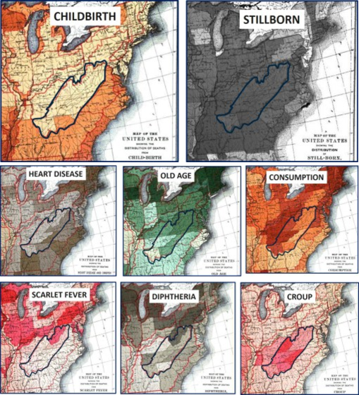
Westward Expansion was well underway.
One direction the US population flowed was directly westward, across the northern edge of Appalachia, through western NY into Ohio and from there over the Illinois and then south the Missouri. We can see the impacts of these populations on diseases or conditions related to population density and increased likelihood for survival. for example the map of "Old Age."
The US population also continued to follow the eastern ocean shores, forming many large cities, but still decades way from establishing a megalopolis. Heart disease hugs the short of part of the Atlantic for this reason. The were some of the most developed parts of the US at the time as well, and demonstrated the impacts of less poverty than the rural mountain regions heading through the Appalachians. Does this mean the northern New England region and Southern Diets weren’t at all good for the heart?
Consumption is a western slope disease. Originally noted to be most prevalent in the NY-New England sector, it managed to head deep into the interior but seemed to like a specific environmental setting. There are two unique strips of this disease, one along the mid-Atlantic oceanic-bays states regions, the other on the western edge of mountain, eastern end of the Great Plains.
Scarlet Fever is very much a population-bound disease, following the migration roads, shipping routes and adjacent railways laid through central Pennsylvania along the Ohio River, staying at the south edge of Ohio, Indiana and then heading back north towards Chicago and the Great Lakes.
Croup wasn’t picky about what side of the mountains it was on. It was just searching for susceptible kids.
Diphtheria for some reason has a more northern tendency. Part of it traverses Pennsylvania, another part follows what seems to be a latitudinally define path, heading north of the mid-latitude line of Ohio, then over the Northern Michigan and Northern Chicago into Wisconsin.
Childbirth is a product of populations and people. The Southern coastal state rates were higher than the northern There are also two very distinct sections of the southern Atlantic states with higher numbers. For obvious reasons, more people are seen living along the coastal regions, so more babies are born there as well. Higher birthrates are on the eastern shore of the Mississippi River in Illinois, not the more rural western shore with larger farms in farmland communities. The shores of the Great Lakes bear more children (shipping towns). From New England to Ohio and lower Illinois, birth rates remain lower than the same longitude down south, along the Gulf of Mexico.
Finally, stillborns were a happening that occurred nearly everywhere. This ubiquitous nature of stillborns in the late 1800s is very different from what I expected for midwest farming communities, the medical school books of which are filled with cases and chapters on teratopathy and birth defects.
See on Scoop.it – Medical GIS Guide
