The patterns are in general Ebola spread somewhat predictable.
When viewed in a global sense, we get a better perspective as to why foreign born diseases inevitably go northward as the season progresses.
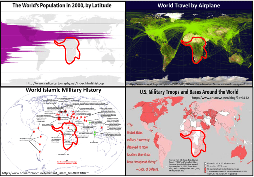
Population density and clustering in relation to the latitude is the reason diseases diffuse from the tropics to the northern temperate zones where more people reside. Any one looking at the above map with population density displayed relative to latitude can figure this out.
But the above basic display of latitude and people relationship took centuries to develop, still longer to make sense in terms of diffusion processes and the importance of spatial epidemiological research.
Source: news.yahoo.com
This vision of how a disease spreads was not to obvious during the 17th and 18th centuries. But through observations, time and travel, doctors and scientists were able to establish what they called the latitude disease diffusion law –known as "The Latitude of Pestilence Law" in 1814. This relationship was first described by geographers trying to describe how the yellow fever made its way in a seasonal fashion to the young United States in the way it did during the early to mid-19th century (https://brianaltonenmph.com/gis/historical-medical-geography/1814-the-latitude-of-pestilence/ ). Yellow fever was the nation’s new "plague" (the in fact called it "the black plague").
Latitude worked in helping to explain its behavior relative to time of the year, seasons and climate. During the 1860s, British military physician and geographer Robert Lawson went one step further by trying to explain the remaining observations about latitudinal diseases based on his rendering of a new longitudinal disease theory. He used the recently discovered global magnetic field flux behaviors, following a north-south pole route, to explain the deviations that were occurring in disease patterns (https://brianaltonenmph.com/gis/historical-disease-maps/robert-lawsons-pandemic-waves-theory-and-map-ca-1864-1875/ ). He essentially then duplicated Faraday’s map renderings of the ever-changing terrestrial magnetism lines, re-naming them "Pandemic Isoclines" on his disease map.
For several centuries now, scientists and doctors have observed diseases travel from the tropics to the temperate zones of the world. These earliest reasons given for this migration based temperatures and climate during the 1700s and 1800s were transformed into a host-vector-pathogen theory and a sanitation theory by the 1880s.
In either case, the migration of certain diseases remained south to north, beginning at or below the equator, and initiating in less developed tropical and southern temperate zone developing countries. Today we define this to be due to an ecological theory involving all of the carriers and initiators of these illnesses.
The distribution of global population and population density patterns in the upper left map, displayed here, demonstrates how and why this migration happens, and shows us that it is in fact inevitable in a sense. There are less people to be impacted by a disease that travels south, much more to the north. Thus the survival of the pathogen and its end product for us–vectored and non-vectored viral and bacterial diseases. Transportation of hosts and vectors, by air, water, ship, plane, or infected humans, defines the changes in longitudinal distributions for these public health concerns.
