Influenza When the Influenza epidemics struck New York and Ricketson’s immediate community, it occurred at a time of the year that was persistent, but very different from the more common febrile ep…
Source: brianaltonenmph.com
How did we come to learn the uses for epidemiology and disease mapping?
Yellow Fever certainly had its influence, as demonstrated by the first ever map of cases produced by New York’s physician, Valentine Seaman. Seaman’s purpose was to determine if the yellow fever came from the ships landing in the ports nearby, following their arrival from Jamaica and other warmer climate settings, or if it was due to local climate and wind patterns.
But the months of late summer and early fall weren’t the only time that doctors were trying to map particular disease. The Influenza, sometimes referred to as a severe catarrh or ’bout with the cold’, was an upper respiratory disease that often struck New Yorkers about the same time of the year, right after the Yellow Fever season was over.
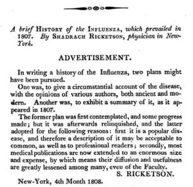
Quaker physician Shadrach Ricketson wrote about these seasonal disease events and their semi-predictability numerous times, most of these items published in the Medical Repository.
His most famous, most commonly used term for this sometimes warmer spells of November into December was "Indian Summer." Indian Summer meant that autumnal fevers could re-emerge.
There is one particular research project Ricketson initiated which was quite unique. He sent hundreds of letters (by the slower horseback and wagoneer mail delivery to postal offices back then). They were addressed to his medical colleagues around the state of New York.
Dr. Ricketson asked these physician s about the influenza and how it behaved by the seasons, changes in weather and other natural events. Most of the physicians of the state had responded, representing most of the state. He then published his essay on this study, a first of its kind.
This same procedure for analyzing disease pattern geography became the standards over the next several decades, and became a regular activity engaged in several times per year by regional and state medical boards by the 1870s.
See on Scoop.it – Medical GIS Guide

October 31, 2014 at 7:15 am
Dr. Ricketson’s study was not entirely the first of its kind. See my articles on influenza research in eighteenth-century Britain at http://www.contagionism.org/influenza_research.pdf and http://www.contagionism.org/influenza_conceptualization.pdf . Margaret
November 9, 2014 at 2:02 am
These are very helpful articles, thanks.
I need to recheck my wording. I was trying to emphasize Ricketson’s work as a first for NY/regional US, not a global first. Because of the underlying philosophy and requirements for testing it, you had to live at a certain latitude (temperate to arctic region). But like always, there were many others going down the same intellectual paths then, and Great Britain was ahead a lot of the time, except for the truly American experiences (the yellow fever period).
Still, Russia and the Prussian sector of Europe were just as successful with their medical geography accomplishments. And the German/Prussian mappers were in fact slightly more successful; Schnurrer made the first map on global medical geography and disease patterns (ca 1823/5, https://brianaltonenmph.com/gis/historical-disease-maps/friedrich-schnurrers-charte-uber-die-geographische-ausbreitung-der-krankheiten-1827/) and the only complete nosology of medical geography/climatology was Prussian born (https://brianaltonenmph.com/gis/historical-medical-geography/dr-carl-friedrich-canstatts-handbuch-der-mediziniche/ ); it never made its way into the English writings or demonstrate much impact.
I think language barriers prevented us from having a complete history of where some of the first discoveries were made. Since Google Books are international, it allows researchers to find out what the others were thinking back then, if you have the time to read and translate.