New Netherlands and the Mauritius River

1610/1611
Introduction
Defining New Netherlands and the Hudson Valley is a process that requires one to be part historian, part naturalist, part scientist and part philosopher. The Valley of the Mauritius River, the North River, the Groote River, the New Rhine River, Hudson’s River, or the Hudson River are all defined quite differently by different writers. That part of the colony or province that most writers agree bears the name of “New Netherlands” and later “New York” is that part of New York that takes you from the lower end of Manhattan Island to the State Capitol of Albany. Whether or not someone can define that part of New Netherlands or New York that extend beyond the Hudson Valley, however, is a completely different question.

For the most part we historians are in agreement that the Hudson Valley is part of an area that is culturally and historically distinct from its surrounding regions, in which the traditiona Dutch culture of New Netherlands still exists in some shape or form. Yet even here, there are differences in the observations and discoveries we make when exploring this region to define our borders of the Hudson Valley and the extent of its Dutch tradition. Whereas scientists’ definitions of the Valley focus on topography, rock formations, watersheds, changes in elevation, and land surface features, the definitions for the Hudson Valley by a geographer are based upon some unique combination of topographic, hydrologic, demographic, cultural, and/or political features available for consideration at the time. One of the most interesting features of Hudson Valley as a special geographic place or area is that, in the end, history has to come into play with regards to defining the Valley’s culture, but is only partially referred to in most of these writings. Even though history is primarily responsible for how the Valley was at first defined, we rely little upon Dutch history when we try to define the valley’s political and social boundaries.
Fortunately, only scientifically-minded Hudson Valley writers take the scientific approach to defining the valley. Most Hudson Valley writers rely mostly on the humanist approach to defining this region, in which sociological and cultural information is used. It is for this reason that the many contemporary interpretations of the valley still exist are very much focused on the Dutch heritage of this region. This is why what the Dutch tradition of the valley means to contemporary residents still plays an role in their local economy and lifestyles. According to writer Maud Wilder Goodwin, author of Dutch and English on the Hudson (Yale Chronicles, 1919), it was the Dutch founding of New York that made New York, and I might add–the Valley, what it still is today. It is perhaps Maud Wilder Goodwin’s depiction of the valley that we should use to define the Hudson Valley and its Dutch tradition.

According to most of my work on the history of culture and medicine in the Hudson Valley region, this Dutch heritage is why the Valley played a very important role in New York history, its present culture and economy, and is why the valley played a pivotal role in Colonial and United States medical history. The multiculturalism of New Amsterdam (New York City) is due to its Dutch creation, Dutch background, and ongoing Dutch influences, and not the result of any of Sir Walter Raleigh’s or King James’s political prowess. The most important role that Dutch history played in the establishment of local medical professions and practices, in the long run, turned the Hudson Valley into the center of multicultural influence, the center of diversity if lifestyle and health-related practices, and in contemporary terms, the center of the birth of alternative medical thinking in the New World, be it the result of the French Revolution during the late 18th century and early nineteenth century, or during the rises in popularity that took place for such unique healing practices as Native American herbal medicine, medical electricity, Thomsonianism, animal magnetism, or the various forms of psychological healing engaged in by Orson Fowler and his followers. Hudson Valley medicine is very different from those of other parts of this country. Whereas for much of the country traditional British medicine prevailed throughout local history into modern day, in former New Netherlands English medicine often took second or third stage to Dutch medicine, followed by Early American medicine.
Maps provide us with much insight into this important aspect of contemporary New York history. In a cultural geographic sense, it is the borderland-hinterland nature and lifestyle of valley residents that enabled them to develop their unique personal philosophies and professional medical practices. This borderland-hinterland line of reasoning for why and how alternative medical professions form is not something I myself was able to define. Early cultural geographers already noted the borderland and hinterland effects upon societies and culture. For the most part it was due to my research and my need to put my findings into perspective regarding human behavior, disease and medicine that led to this realization that some sort of boundaries is why so much of the valley history of medicine is so eclectic in nature. Many Hudson valley physicians were very unlike those of the regular medical practices in and around New York city, and even when they tried to conform with other more “regular” MDs, this still resulted in outcomes and traditions that were very much out of line with professional standards.
Modern definitions for the Valley and Dutch culture
When culture, history and the population of the valley are taken into consideration, arguments for how to best define the Hudson Valley in a modern sense become less scientific and more humanistic. For this reason, the only portions of the valley which the majority of us accept as an actual part of the Hudson Valley region are thoses pieces of land located somewhere between 10 and 20 miles from each edge of the Hudson River, extending from its center somewhere near Poughkeepsie northward towards Albany, for at least part of the way, and southward towards New York city, which for many of us is usually most of the way. The” valley” part of Hudson Valley is lost once you get close to either edges of these regions where many of the scientific borders are defined based on watershed boundaries, such as the edges of the Shawangunk and Catskill and somewhere close to ranges at the current Connecticut border. To most travelers, explorers and curiosity seekers making their way along the valley, this valley extends through just the counties that are in direct contact with the river’s edge.
Now, if we relate this modern cultural interpretation of the Hudson Valley to New Netherlands history as a whole, with the goal of better understanding the impacts Dutch culture had upon the entire state, we have much the same problems to contend with, only projected several times greater in size due to early explorers and settlers who tried to a place they could call New Netherlands (at times as New Belgium and New Holland as well). In a colonial sense, only the heart of that portion of the New World known as New Netherland is the Hudson Valley.
The rest of New Netherland extends as far north and west as the border of New France, as far north and east as the border of New England, and as far south in all directions right up to the northern edge of the English Colony of Virginia.

Of course, the Hudson Valley was not always considered a part of New Netherland. Following the surrender of this land to England in exchange for maintaining hold of Surinam to the south, the Dutch managed to relinquish its rights to further legal holds on this region, with minimal loss to the Dutch culture and tradition of this area. In the following map published in the London Magazine in 1765, nearly a century into English domination of this land, at least in a political sense, New France still managed to serve as one of the most important neighbors to the New York-Hudson Valley region, at both the northern and western edges.

In this map we see that New France has moved its southern boundary over New York significantly north of the old fort near Albany, pretty much to the St. Lawrence Seaway. The various regions of British domain extend into and, in some longitudinal regions, over the tops of the Appalachian Mountains on down to the Smokey Mountains. Other parts of New Britain are by now defined as well in parts of Canada, extending from New Scotland located in the most northeast portion of New France claims but culturally, a part of the extension of British-owned and occupied New England. The naming of new South Wales and James Bay north of New France also make a political statement about the ultimate goals and desires the British had for possessing the parts of New France just south of these regions. Meanwhile, New France has still maintained claims on lands along the southern edge of the Mississippi River, as far south as the Guld of Mexico. Due to the absence of British prominence more than exploration and claims of possession by its opponents, the French and Spanish fleets, the lands between New France and New England in the Georgia area are considered by this British cartographer to be of New Spain domain, its original claimant.
![]()
New Netherlands versus New France and New England
To the north of New Netherlands was New England, to the South was either Virginia (also owned by Great Britain) or New Sweden, depending upon the year and who you were more likely to believe in or pay the most respect for, and to the North/Northwest was New France. To the west of New Netherlands was either New France, or part of the Louisiana tract (for French leader, King Louis) depending on how much you considered this part of the continent part to of the European domain.
The following satellite image depicts parts of New England, New France, New Netherlands/New Belgium, Virginia/New Britain, and parts of New Scotland, and New Sweden. By a simple review of this image can you tell where the boudaries of these territories lie? How do you describe these edges or boundaires based on this view taken from above? Which topographic features are also most likely visible at ground level, and so used to define these political boundaries in the original colonial land claims?

Generally speaking, if a particular feature is visible from above, it most likely played a role in the local land claims process. Examples of these topographic delineators include: the Hudson River, the Adirondacks, the Catskills, the Shawwangunks, Green Mountains, the Great Lakes, the Saint Lawrence Seaway, the Finger Lakes, Lake Champlain, the Connecticut River, parts of the Susquehanna and Alleghany Rivers, Long Island, etc.
Which of these parts in and around New York were most accessible? Where were the most navigable and useful portions of New Netherlands located? Where were the theoretical boundaries of New Netherlands located based on the accessibility and inhabitability of its inland regions?
The next map of New England was originally published as part of Smith’s Description of New England in 1616. Important to note is the westward most extent of this depiction of the prior British land claim of this territory made by Sir Walter Raleigh. A significant portion of it appears in the above satellite image.

In a much later textbook on geography, Josiah Shinn’s History of the American People (American Book Company, New York, 1893, 1899), this map was simplified to further clarify the meaning and reconstruction of its boundaries, as follows:

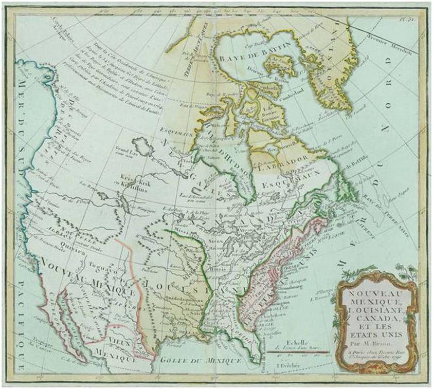
The boundaries of New France are more diverse and varying both spatially and temporally. Contemporary politics define New France based on the boundaries of its successor Canada. As noted in the following map, (dated 1790 no less), the territory once claimed by New France, now in possession of British powers, extended significantly across the North American continent. During the periods of possession claimed by each, original borders extended significantly in all directions, as far south as Louisiana by way of the Great Lakes and southward along the Mississippi River, as far west as the cartographers eyes could see and hands could draw, and eastward towards the New England-New Netherlands areas, as far south as the colonized and settled boundaries were for each. During the period in which Canada was owned and possessed by France, there was a little bit of indecisiveness regarding the New England-New France boundary. In New Netherlands, the delineation of these boundaries became more a squatter’s rights issue, involving not only European settlers from each of the two countries, but also some Native American communities or groups. In New England, this issue ultimately became a matter decided upon in both legal and military fashion.

![]()
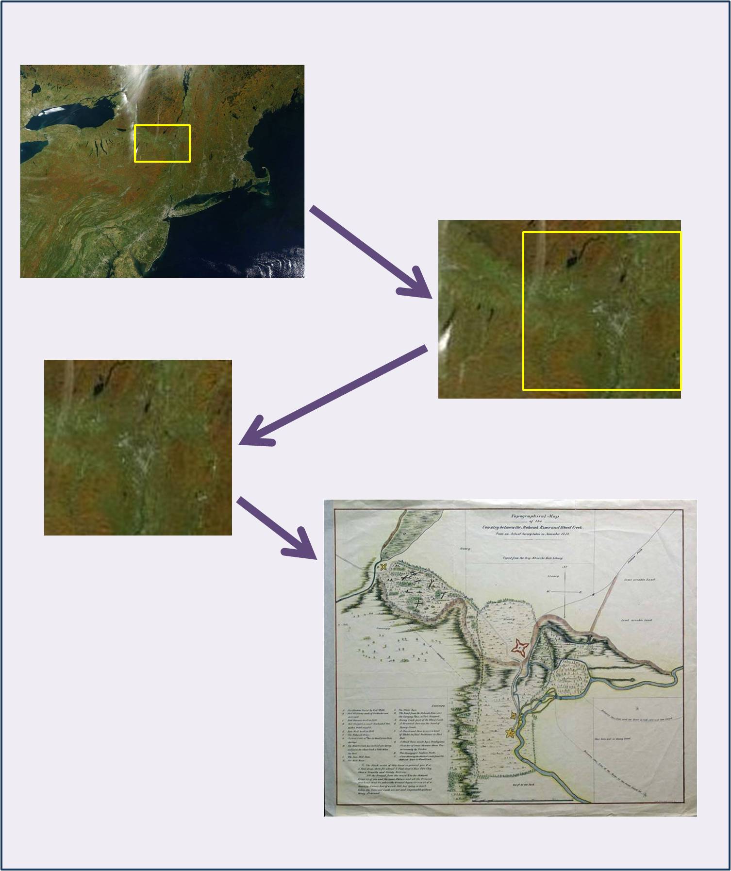
The Northern Limits of New Netherlands
The Northern limits of New Netherland along the Hudson River have been discussed several times in original historical writings of this aspect of local history. In general, the fort near Albany has been considered close to the border of New France and New Netherlands. Various accounts of this place describe different settlement histories, and provide different renderings of the fortresses built at this location. In some reviews of this place near Albany, the fortress is defined as being either Mohawk or Ononadaga in origin. Its earliest non-Native settlement has been described as being French in nature, but its more important settlement periods are mostly Dutch in nature until the capture of New Netherlands by the English about 1686/1689.
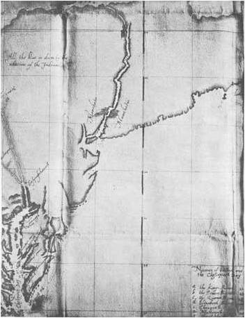
The following is a depiction of this area, the joining of the Mohawk River and the Hudson River, found in O’Callaghan’s series of New Netherlands/New York writings. Once an important part of Iroquois culture, followed by early 17th century and possibly late 16th century French culture for this topgraphic setting, this location became a prime Dutch possession until its reliquishment to the British several decades later along with the rest of the New Netherlands.


![]()
New Netherlands versus New Sweden

An often forgotten part of Dutch history in the New World is the relation of New Netherlands to New Sweden. The plan to form New Sweden was initiated under the leadership Scandinavian King Gustavus Adolphus II, who was subsequently succeeded by his daughter Christina by the time the first of these voyages were initiated. In 1638, Scandinavian ships Kalmar Nyckel and Fogel Grip made their way secretively towards the New World and headed inland along the Delaware River to lay a Scandinavian settlement in the Delaware Valley. This settlement was occupied by Swedes and Finns, mostly men in charge of erecting the first fortress in this region which they called Fort Christina (builtin in the current setting for Wilmington). The Captain of these excursions was none other than Peter Minuit, the captain in charge of the first ships responsible for the occupation of Manhattan Island and former governor of New Amsterdam. Over the next seventeen years, approximately 600 Swedes and Finns settled this region and nearby towns formed along Delaware Bay’s shores.
From 1643 to 1653, Johan Printz governed this community, helping in the establishment of fortresses on both sides of the Delaware Bay and River, and keeping peace with the neighboring Dutch settlers in New Jersey and the local Native American group–Lenni Lenapi. Following the establishment of Fort Elfsburg on the New Jersey (Dutch) side of the Bay, political tensions began to increase between the Dutch and Swedish. this along with Printz manner of governing his people led him to leave office in 1654, when he was replaced by Johan Rising. Soonafter taking his governing position, Rising tried to remove Dutch settlers occupying their fort in Fort Casimir (subsequently named Fort Trinity). This led to a confrontation with New Amsterdam’s Governor Peter Stuyvesant, who in just a few months managed to recruit enough soldiers to reclaim the land and forts occupied by New Sweden’s settlers by the end of that year. In turn, Governor Stuyvesant allowed the Swedes and Finns to retain their lands and dwellings, which remained under Dutch control and the region renamed “Swedish Nation” until 1681.
In 1681, William Penn obtained his charter for Pennsylvania. This also included the Swedish nation territory and the remaining land extending directly southward along the coastline that form the present day state of Delaware. Soonafter this gubernatorial change, the tolerance of Stuyvesant and Penn of these multicultural, polyreligious settings facilitated further development of this region. The crossings of Dutch and Scandanavia traditions in this region were plentiful, although limited in terms of written documentation of this transformation of the region. In 1683, a letter sent “By Thomas Paskell of Pennsilvania to his friend J.J. of Chippenham” was republished as a pamphlet and dispersed throughout London by printer John Bringhurst. This pamphlet included a description of this part of North America, retold in the usual fashion. Of particular importance to the Swedish and Finnish tradition of this land was the abundance of agricultural and forest resources for this land. As a part of this letter, Paskell noted:
“The land is generally good and yet there is some but ordinary and barren ground. Here are swamps which the Swedes prize much and many will want: And one thing more I shall tell you; I know a man together with two or three more, that have happened upon a piece of Land of some Hundred Acres, that is all cleare, without Trees, Bushes, stumps, that may be Plowed without let, the further a Man goes into the Countrey, the more such Land they find. There is also good Land, full of large and small Trees, and some good Land, few trees on it.”
Scandinavians continued to inhabit this region for generations to come, with subsequent settlements established in the more rural parts of this region as well. The impacts of these settlers on the local demographic and ecologic features of this region were again covered in detail by Pehr Kalm, himself Swedish, as part of his journal through and exploration of these lands in 1748 and 1749. Kalm’s tales were published in 1750, in Travels of North America. This book provides us with significant evidence for the cultural impact impacts scandinavian settlers had upon this region.
Unlike the English and French settlements, there was limited competition and even brief periods of skirmishing between Dutch and Scandanavian communities. And there were also significant differences in eating and health-maintenance patterns practices by each of these two cultures, as evidence by Kalm’s writings. Some of these bits and pieces of Scandinavian culture Scandinavian even spread into the Hudson Valley during the 17th and 18th centuries, but for the most part many of the occupations and family patterns typical of one community seemed to have their parallels within the other community settings, rather than be a discovery made by one cultural group that is then passed on to the next. (More on the specifics about these ethnobotanical notes are to be placed elsewhere in this blogsite.) In the entries into his journal dated March 27th, 1749, he discusses the status of Swedes and Finns and New Sweden at this point in colonial history. Major ecologic changes included the diminishment of highly productive fodderlands and timberlands, and a “decrease in the numbers of birds and fish.”
 Source: Wikipedia
Topographically, it helps to consider the parallels in land topography that assisted the Swedes and Finns in deciding to occupy this region. Sweden, surrounded by large inlets and fjords, had many of the same features as the Delaware Bay. The massive forested lands were much like the conifer-rich forests precious to Scandinavia and especially Finnish culture. Like the Dutch, Scandinavians felt they were more adapted than the British to the climate and topography of the inland portions of the Mid-Atlantic colonies of New York, New Jersey and Pennsylvania. At least this was part of the philosophy held by the earliest settlers of the New Jersey-New York areas influenced by Finnish and Swedish settlers. A common feature of colonial philosophy is this topographic-based reasoning for selecting your first settlement locations. This is often the reason, in fact, whereas one country makes claims to a particular section of land, but then only settles a very small section of this territory, that other countries and cultural ground that feel more adapted to the local natural setting actually form the first communities raised in many of these colonial regions. This is not the only rule people follow when selecting their new place to reside, but to many it becomes a more important personal line of reasoning used in determining whether you wish to reside along the shorelines, next to possible growing fields, or deep within forested land on some mountain setting.

Details of this part of New World History are at:
- http://www.colonialswedes.org/History/History.html
- http://en.wikipedia.org/wiki/New_Sweden
- http://www.ithaca.edu/staff/jhenderson/kalmar.html
- http://en.wikipedia.org/wiki/Fjords
- http://en.wikipedia.org/wiki/Hudson_River
Note: A couple of sites I reviewed mentioned there is very little if any influence of New Sweden and the Swedish-Finnish history of the New Sweden area upon contemporary culture and local histories. This is kind of an irresponsible claim if any of these sites are to be used for teaching purposes. The “absence” of cultural influences at a political and overall sociocultural level demonstrates disregard for the contributions made by smaller populations. It is always better to evaluate cultural impacts at the household-neighborhood and/or hamlet-village level on up. Exceptionally small ethnic groups are often covered with regard to teachings developed on South American and North America indigenous. A good qualitative analyst method can make sense at the case-by-case, individual and focus group so too can the American ethnologist or historian. The reasons for this inconsistency in the teaching philosophy as it appears on the web are quite puzzling.

![]()
Historical Maps
The following maps are meant to illustrate where the Dutch influences took hold of the local New Netherlands-New York-Tristate areas for centuries to come. The heart of most of these influences are anchored somewhere along the river along the Hudson Valley. But due to the combined ethnic and gubernatorial histories of the Valley, various cultures were used to define the local lifestyle practices. As earlier writers have stated, it is the underlying multicultural nature of the founding Country of New Netherlands itself that enabled interculture practices to be developed for generations to come in both New Netherlands, and later the British possession of New York. The mixture of cultures and communities forming the United Netherlands are those which are primarily responsible for what this region is today, a Valley of many names and a people of many backgrounds cultures.

1613/1614, Cornelis Doestz

1621 (from O"Callaghan's series on the History of the New Netherlands)

Close-up of the New Netherlands area

1650, Jannson-Visscher
In the 1650 Jannson-Vicher map, Novi Belgii, important things to note include the use of pastel colors (water colors?) to define “regions” according to the cartographer’s impression. The large teritories defined are ‘America Septentrionalas Pars’, ‘Virginia Pars,’ ‘Penn Sylvania’, ‘Nieuw Nederlandt’, ‘Nieuw Jorck’, ‘Nova Belgica’,’Nova Scotia’, ‘Nieuw Enge Landt’, ‘Nova Francis Pars’, ‘t’Longe Eylandt’, and ‘Nova Guernsey’, to name a few. Important physiographic “mistakes in interpretation” pertaining to major landforms and water features include the placement of a single grand lake east of the Connecticut River and well south of the major east to west Canadian waterway–the St. Lawrence Seaway, and the bifurcation of St. Lawrence in an area north of what could be considered the Massachusetts portion of New England. In addition, an original border between New England is New Netherland inferred by the pastel patterns–the most prominent north-south feature of this region–the Hudson River–was used to define this border; this border was later moved eastward towards a narrow mountain range; today this range helps to define the state border of Connecticut and New York.
Another important feature to note is the sharing of colors for Nantucket Island and Long Island (both are darker green). Martha’s Vineyard seems to lack any claims based on its assigned color. Similar color patterns have also been assigned to New England, New Jersey and the large area of Virginia, suggesting knowledge about British domain in these regions. The boundary between Pennsylvania and New Netherlands lacks a detailed dividing line, more than likely due to the fairly scarce information available about this region.

1656

1671 version, Novi Belgii, Novi Jorck, John Ogilby

1685 Reprint of 1653 Novi Belgii

Another rendering of 1685

Black and White Topographic map, ca. 1800
