The raising of new buildings over the graves and bodies of at least fifteen well-documented, and as many as more than two hundred proposed burials, in the old revolutionary war military storage depot, training, and soldiers’ encampment site ordered by George Washington around May or June 1776, dishonors not only the soldiers who died there, along with their spouses and family members, and any local descendants still residing nearby, it demonstrates disrespect for the single, most important part of this nation’s birth and heritage.
Until the war began, the small village of Fishkill, less than a mile north of this camp along the old post road, served mostly as a hamlet providing important services to travelers of roads connecting Albany to New York, Pennsylvania with Connecticut and Massachusetts. When the Revolutionary War began, it became one of several villages for colonists to retreat to. Those who retreated, travelling north after the City of New York was occupied by the British in December 1776, included a number of politicians, investors, businessmen, printers, tradesmen, and manufacturers. They turned the village of Fishkill, situated inland from the river and east of Fishkill Landing, into a military center where military orders, laws, ordinances, governmental papers, and paper currency were printed. Numerous businesses were established in the region for the manufacturing of raw textiles, military clothing, cordage, ships, chains, anchors, naval stores, military wares, rifles, gunpowder, artillery, lead balls, swords, livestock and horse feed, medicines and foods.
The controversy about the Fishkill site as it is described by the most recent developer includes statements denying the presence of ample evidence for graves or buildings on the tract of land that is to be redeveloped. The evidence provided for this relies heavily upon the lack of ample physical evidence suggesting that significant settlements were at all laid upon this tract of land, or that significant archeological remains exist. These two claims are based upon incomplete reviews of the site or simple opinions voiced by reviewers of the site. These conclusions are not based upon a total review of the area, through the most contemporary means for remote and proximal sensing, or by way of a complete archeological assessment of this area.
Previous reviews illustrate the presence of foundation stones, upon which walls were constructed. The remaining areas of this encampment are noted or inferred numerous times to be constructed either as “tents” in the beginning or as “huts” constructed with local wood, textiles and other materials. As noted by one of the key historians in the organization established to preserve this property, Rad Curdy, whatever material was used to make these buildings were later removed or torn down by the locals, who used these materials to improve their own homesteads. This use is also an argument and convincing statement made by leaders in Washington’s army to obtain support and approval of the development of this and any other places developed into military encampments during this or any other subsequent war.
So, the long term use of this region and the recounts of as many as “hundreds” of soldiers buried at this site in 1866, imply that this area in need of review is of substantial size. Considering the topography of the immediate region, it is also reasonable to assume that much of the property around what is currently the Rte 84 Overpass, heading north, east, south and west for one to two miles, provided ample space for other military related events to follow. The most important of these events would be the military training sessions provided by Baron von Steuben and the formal inspections given by Marquis de Lafayette.
The developer also demonstrates some insensitivity towards the families of soldiers buried here, the families of soldiers probably or possibly buried here, and the heritage underlying each of these families according to recent research performed by historian Judy Wolf. Wolf’s research resulted in the identification of several important soldiers noted for this site, negro soldiers fighting for the cause of a new nation. This complements important roles played by other cultural groups serving under George Washington, ranging from French and Hessian soldiers to the Scottish Highlanders and Ninham’s American Indian-Metis (“halfbreed”) regiment.
This decision by the developer to not honor this part of our multicultural heritage is neither criticized not commented upon by the town board or town historians. This lack of interest is also demonstrated behaviorally by county historian Wm. P. Tatum III, who has not made a public statement on this matter, nor the very quiet and disengaged New York State historian Devin Lander.
According to Paul Grondahl in Times Union newspaper, (Sunday July 10, 2016):
“The normally placid pool of local historians has been roiled by a downgrading of the state historian position that critics consider an affront and a further diminishment of history’s role in the wider culture.” (www/timesunion.com/tuplus-local/article/Downgraded-New-York-State-Historian-stirs-ruckus-8351280.php) .
To be fair in these criticisms, it is important to note that the general public has been very unreactive to these issues in general. We barely have enough time to raise a family, assist in its growth and development, so how is it we can find the time to assist local history–especially when they have little to no impact on state or local politicians?
Everyone is to blame perhaps for the disengagement people have towards their town’s, family’s or personal history.
And so, this epitaph I refer to in the title, the one carved into stone by the developer and/or town board might read:
Behold and see as you pass by
As you are now, so once was I
As I am now, you soon will be
So prepare for death,
and be forgotten like me.
Brian Altonen, MS MPH PHD(ABD)
126 Spring Valley St
Beacon NY 12508
September 24, 2017
Fishkill Planning Board Department
Att: Mary E Hendricks, Chairperson, and Members of the Planning Board
807 Rte 52
Fishkill NY 12524
Chair Hendricks and Members of the Planning Board:
This letter is a request for placement of the “Continental Commons” property into “Positive Declaration” Status for further review.
It is the opinion of this writer that whether or not the property in question must be protected from developers has yet to be determined.
For more than 35 years, I have been active as a researcher, lecturer, research associate, adjunct professor and published writer on the history of medicine and the history of Hudson Valley. I am a specialist in historical medical geography and environmental health. I am an internationally published expert in medical history and epidemiology, and am recognized as the expert is the history of disease mapping and the spatial analysis of disease outbreaks. I currently work as a spatial population health analyst for NYC Health + Hospitals [9-10 million patient medical histories].
My interest in the history of the “Continental Commons” property extends back to 1974. I was a member and leader of the Boy Scouts from Troop 1756 sponsored by Trinity Episcopal Church, Fishkill, NY. During the immediate pre-bicentennial years, we [the troop] developed and sponsored regular programs and presentations devoted to the role of Fishkill and the local Revolutionary War encampment site in the history of the War. The best known of these programs focused on Enoch Crosby the Spy, and included performances of his capture and escape, and local reviews and talks focused on Samuel Loudon’s activities, and the role that churches played as meeting places, prisons and hospitals during the War.
During this time, we were under the direction of the locally famous Dr. Felix Scardepane (b1897-d1998), who served as president of the Van Wyck-Wharton House organization for a number of years. His organization provided the oversight needed to preserve and develop this portion of the Fishkill village into a national historical site for tourists to visit. This plan received the support and respect of the town’s historians and historical society, and possibly the Town Board.
Under the auspices of Dr. Scardepane, when plans to develop Mays Department Store were initiated around 1974, an archeological assessment of this area ensued, resulting in a detailed review of portions of this site, accompanied by a publication of the comprehensive history of this site by Rich Goring of NYS Office of Parks & Recreation, Division of Historic Preservation (The Fishkill Supply Depot and Encampment During the Years 1776-1778, December 1975. 44pp. Accessible at https://brianaltonenmph.com/wp-content/uploads/2011/03/fishkill_1975_goring.pdf). This site continued to receive the respect and recognition it deserved from local historians and historical agencies. Developers however demonstrate lack of interest in respecting this town’s local history and value as a nationally recognizable historical site.
The area in question for Continental Commons includes the sites which Dr. Scardepane and Van Wyck Wharton House sponsored and managed the archeological reviews of. In an article published on October 29th, 1973, it is noted that Dr. Scardepane, that he and his son Felix Jr, and the Fishkill Historical Society, had to prevent the destruction of a part of this land by a developer’s “bulldozers”. This protection was supported by the Village’s historian and historical society (see https://www.newspapers.com/newspage/114691963/). From 1973 on, a number of archeological reviews of this site have taken place, the most recent on site archeological inspection being 2013. All of these archeological digs were recently reviewed extensively by Richard W. Hunter and James S. Lee in their report entitled A Historical and Archeological Synthesis of the Fishkill Supply Depot. Town of Fishkill, Dutchess County, New York. (Hunter Research, Grant # GA-2287-14-00, published March 2016). Interpreted in their entirety, they demonstrate that the sum of these archeological assessments only review only a small portion of the entire site planned for the resurfacing or demolition, and development of “Continental Commons”.
No single, comprehensive, archeological review has ever been performed of the complete site. No series of archeological assessments have ever been made of this entire region with the sole purpose of determining its total history. No sizeable evaluation of the site has been made for human remains. No complete search for relics residing in the soil has been made.
On June 16th, July 19th and August 29th I recommended the initiation of more scholastic, academically sponsored approach to reviewing this site due to the discrepancies and mistakes made in the review of this site by the Continental Commons sponsored writers. Their interpretation of the sites history was biased even more by the personal nature of their attack on specific local historians. As part of the recommendations I made to Continental Commons, I ultimately suggested that a more aggressive approach using remote and proximal sensing and raster-based GIS review of the region be attempted. Since my expertise is in medical geography and the use of rasterized imagery in evaluation land surface and subterranean geology, ecology and landuse/archeological history, I even offered my assistance at least once in these statements and requested that such actions be taken to review the actual subterranean portions of this land (see https://www.facebook.com/continentalcommons/?ref=br_rs Reaccessed and confirmed 9/24/17). The respondent to my posting informed me that my assessments of the land were false (although no remote sensing has ever been fully performed there, suggesting they are naïve about this technology and its science). Neither the respondent/Continental Common Developers nor the individuals countering their recommendations have engaged in a complete remote sensing analyses of the region. There is no evidence for local academicians getting engaged in this work, especially the RS-GIS groups and the like (in particular Vassar and New Paltz GIS experts); and perhaps for political reasons, the resources available through the county, region and state GIS programs have not made offers as well.
Another failure in the review of this sites complete history includes the inability of historians to locate the soldiers’ privies, and obtain supporting physical evidence typical of this unique land use feature. Privies used by the military are one of the most important sites in need of archeological review, for the removal and preservation of the typical materials found at these sites such as tools, stone-, glass- and metal wares, and perhaps some biologicals including analyzable human products or samples. There has also never been an identification and unearthing of the official military burial site anticipated for this setting, the existence of which is well supported by primary documents for this military camp (reviewed later) .
In Hunter and Lee’s review of these archeological sites (se figures at end), Area 11 depicts the broadest area most in need of review at this site. Included in this area are significant portions of the former military village setting behind the building referred to as a Stable. The area behind the “Stable” has not been fully assessed as far back as the property border, or as far back as the easternmost edge of this land surface located at the foot of the eastern hill (“mountains”). In my personal review of this area as a published medical geography historian, it is my opinion that a most likely place where remains could be found for as many as several hundred more deceased Revolutionary War soldiers is within this region.
This concern for the possible presence of human remains is a important question not adequately handled by the Continental Commons developers. As an example of a possible outcome of this management process, we need only reflect upon a similar mistake made when the city of New York developed over an early post-Colonial African American grave site. The unearthing of the remains centuries later led to the cessation of further development of this site, and ultimately the establishment of a National Historical Site (see African Burial Ground. A Sacred Space in Manhattan. https;//www.nps.gov/afbg/index.htm ).
Now granted, this site has undergone considerable ecological, land use, and topographic change. Yet, in spite of the fact, no human body remains have ever been unearthed or discovered like in other comparable sites. For example, this 1750 Moravian cemetery in Pine Plains had a missionary leader who was unearthed in the late 19th century due to tilling; this was documented and the condition of the site is known to this day. The opposite is true for another burial site located at the Connecticut-New York border, where unmanaged, rarely used land has since led to the overgrowth of this burial place.
Still, relating this to the Continental Commons site, the presence of soldiers’ graves in this region is well documented, repeatedly since the end of the Revolutionary War. And a review of these land surface features in the form of aerial photography suggests a reason as to why the underground portions of this land may still remain intact. Yet no complete study of this site has even been made.
Changes of this encampment are well documented, as it the rapid, superficial way in which soldiers bodies were buried in this cemetery (i.e. the July 1777 letter from Isaac Ledyard to Amma Cutter noted later). Writings about the wartime and post-war development of this site note some sections that have modified land surface features. They also note the removal of the older buildings raised on this site by soldiers, followed by the subsequent removal of wooden structures or “huts” on this property, as one 18th century traveler referred to them, by the local families recovering from the war. According to local historian Radford Curdy, President of the Dutchess County Historical Society during the 1960s (ref personal communication 1983, Adriance Library), this explains why remains of the stone foundation still exist at this site.
This explanation is further supported by summaries made by Hunter and Lee (2016), and the underground surveillance performed with the support of Hess Gas Station finances several years ago (ref. personal communication Bill Sandy, Friends of Fishkill Supply Depot (FOFSD)]. These findings support the suggestion that archeological remains still exist in this area, and that a full archeological review is required, including archeological digs, soil/groundwater chemical assessments (the trenches are already identified), and the use of multiband proximal and distal hydrological and pedochemistry focused remote sensing ground penetrating radar and terrestrial laser scanning. (See Brian Altonen. West Nile – Remote Sensing. https://brianaltonenmph.com/west-nile/6-remote-sensing/. CA Wilson, DA Davidson, MS Cresser. 2008. Multi-element soil analysis: an assessment of its potential as an aid to archaeological interpretation. School of Biological and Environmental Science, University of Stirling, Scotland. Journal of Archaeological Science, 35(2), 412-424. Accessed at ScienceDirect.com, article S0305440307000866; J. Entwistle, KJW MCaffey, PW Abrahams. 2009. Three-dimensional visualisation: the application of terrestrial laser scanning in the investigation of historical Scottish farming townships. J. Archaeological Sciences, 36(3), 860-866. article S0305440308002768).
Also supporting my claim for the likelihood human bodies remain in this region are several historical reviews of this local importance. During the first years that the Dutchess County Historical Society was established (ca 1914), considerable interest in preserving this site existed, focusing on where the Revolutionary War Soldiers were believed to be buried. According the Historical Society, in the article “The Encampment: The Burial Ground; redoubts (Fishkill, 1916-1918, Dutchess County Historical Society Journal (DCHSJ), 3, 18-22),
“This ground is truly harrowed ground. By the roadside stands a monument, erected by the Daughters of the American Revolution [DAR], calling attention to the fact that in the adjacent field there lie the boned of those who freely gave their lives in the service of their country.”
The DAR monument has since been removed to a new location slightly north of this site by the Van Wyck Homestead. But its original placement on the roadside down by the Maya restaurant serves as a marker for the center of the entire Revolutionary War encampment region established here. The land to the south was used primarily to develop sites for defense of the area, and to guard and secure travelling through who would be passing by the military supplies stored in the Depot just to the north. Therefore, to the south of this old marker site are the defensive and offensive settings needed to prevent penetration of this region by British militia. This use of this southern portion also suggests that had the soldiers been buried here, their graves and memorials could hinder any aggressive movements needed by the military, in turn pointing to land immediately north of this former roadside monument, as the historical writings suggest, as the most likely place for deceased soldiers to be buried.
Whether or not the farming and agricultural related development of this area is also a concern. This site was most likely tended to and developed by the Van Wycks, who, according to early maps, used this property for their documented horticultural business, possibly maintained as open space or grass, hay and fodder growing. Yet, this use would require tilling, and no unearthing of bones is yet noted in the historical writings.
But because this area is open space, it remains easy to recognize on the areal photographs published in a Hunter Research report (Richard W. Hunter, James S. Lee. A Historical and Archeological Synthesis of the Fishkill Supply Depot. Town of Fishkill, Dutchess County, New York. Hunter Research, Grant # GA-2287-14-00, published March 2016. See pages 2-22 to 2-24, Figures 2.9, 2.10 and 2.11 entitled ‘GIS in Dutchess County. Aerial Photograph of the Fishkill Supply Depot Area. . . . 1936, 1955 and 1970 . . . . ).
Looking elsewhere on this property (noted and detailed later as “area 11”), a possible burial site could be located between Snook Road and Van Wyck (Lake) Road, adjacent to Route 9, just inside the south end of this plot is the rivulet Raiche Run, as noted on the first second and third photographs. In the second aerial photograph, Raiche Run passes by the southwest corner of the property in question, where a possible shed then stood. Due to further development, several structures were built adjacent to Route 9, on the northern third west edge section of this lot; and much later, when this piece of land was developed into the gas station located at the corner of Route 9 and Snook Road, the moved soil, in piles located behind the gas station, has never been complete reviewed for possible human or other physical remains (re Personal Communication Bill Sandy, archaeologist).
As previously stated, the Maya Café constructed south of the area in question was situated in the middle of this entire region settled by militia. To the south were fortressed settings and initially, two large older barracks, which were later removed, or replaced by similar structures to the north.
In the Hunter and Lee map depicting the history of the archeological sites assessed for this area, the section identified as Area 11 is most important to note. This area, and an undefined section located immediately adjacent to it on the eastern edge, extending into the hillsides, best define the area where other soldiers may have been buried.
Recounts of the tales about this cemetery indicate this burial site was located at the base of mountains. Most of the land in question for development extends well into the wooded area, across flat lands, ending at the base on the hill where soldiers may be buried. Sections of the west side of area 15 have been partially reviewed; sections of the east end have not been equally assessed. At least one of these assessments (performed remotely via GPR) suggested the possibility that human body remains changed the nature of the layers that were formed beneath the ground surface.
Another study to note is that of Temple University (Area 4 on the archeological map), and the adjacent areas 17 and 16 also reviewed by Hartgen and Associates. The smaller regions have been partially excavated by Temple University Students, and demonstrate evidence for the stone-foundation supported “huts” defined by other writers passing by this military village during the War years. These regions were also investigated by Hartgen Archeological Associates in 2011, and the areas reviewed by Radar Solutions International, Inc. in 2012 and 2013. Each of the regions mentioned are contained within the single parcel (Area 11) identified, researched and assessed by Greenhouse Consultants, Inc., five times from 1998 to 2009. Together these suggest that the area(s) directly adjacent to Area 15 and the purported 15 burial sites, extending eastward behind the documented “Stable” location, requires a more detailed scientific, archeological reassessment.
A number of theories may be given for the scanty, yet reliable, documentation that exists for the burial of the soldiers in this setting. An argument against their burial south of Area 11 and south of the Maya Café, suggested earlier, is that the area available for burials is much less, and the need for use of this region for guarding, surveillance and defensive movements, should enemy troops travel by land from the south, through the ravine that exists below. Such a place would be hazardous were loosely laid or piles or stones, headstones, or wooden plaques and crossed-branches be raised in this section. It is possible that burials occurred quite quickly, due to the large numbers of deaths, as documented in one reflection of experiences following the White Plains battle. A fairly persistent, recurring epidemic may also result in barely marked cemeteries. (Most often small pox behaved in this manner, but also water based pathogens related to dysentery and opportunistic dysentery were possible).
Aside from the possibility of a “Soldier’s Burial Ground”, there are several other non-human burial related uses of this region by the military that provide it with an unusual history, unmatched by most other revolutionary war preservations sites.
In an Address delivered to the Fishkill Historical Society on October 14, 1967, Society President Radford B. Curdy noted the many services Fishkill provided to General Washington through the years of the Revolutionary War. This site was where a number of government and Military Officers, Directors and Generals met, including Congressional President John Jay and military representatives of major forces serving the Northern and Mid-Atlantic states. He defined the single most important feature of this site, when compared with other Revolutionary War sites, was its service as a central source for military supplies, managed and directed for two years by the Massachusetts Quartermaster-Commissary, in charge of both supplies and manpower for troops both north and south of this location. The Deputy Quartermaster Generals for New Jersey, Pennsylvania, Massachusetts, Connecticut and New Hampshire relied upon this resource, for iron, wood and fiber generated supplies, along with the products of blacksmiths, and some of the most important artillery and medical stores. According to Curdy,
“[T]his site that needs to be preserved as much as possible in its entirety for restoration-reconstruction of this complex, to preserve for future generations to value, this neglected phase of our Revolutionary War heritage. Nowhere else in this country is there a Quartermaster or Commissary Post of such importance better suited for this than Fishkill.” (“The Breadbasket of the Revolution Past and Future”, Dutchess County Historical Society Yearbook, 45-48.)
Even earlier, in 1866, James E Dean of Fishkill, and John W Spaight of Fishkill Landing (now Beacon), in their book Historical Sketch and Directory of the Town of Fishkill . . . (Printed at Standard Office, Fishkill Landing, NY, 1866, p. 84), wrote:
“Many poor patriot soldier’s bones lie smouldering there; and, how many, if we did not know this, we should be startled at their magnitude—This almost unknown and unnoticed burial ground holds not a few, but hundreds of those who gave their lives for the cause of American Independence.”
Although published more than 80 years since the Revolution, there were still people who could be interviewed by these authors regarding the events that took place in Fishkill, and at the Military Encampment located a half-mile south of the village. One example is the elderly lady who was interviewed fifteen years earlier (this is refuted by Rad Curdy however in his previously quoted presentation).
Then “living at an advanced age”, this lady spoke about her experience as a child, when she and her father travelled through the village along the old post road. She claims they passing by corpses “piled as high a cord wood”, between Old Dutch Reformed and Trinity churches, casualties of the battle of White Plains. According to her, these soldiers were buried at “the Soldier’s Burial Ground”, which according to the Dean and Spaight was located “[n]ear the residence of Mr. Sidney E. Van Wyck, by the large Black Walnut trees, and east of the road near the base of the mountain.”
According to the authors, and the lady, this site also included the bodies of “the wounded of the battle who afterwards died”, “[t]he constant stream of death from the hospitals . . . “, and “many more” produced by “the Small pox which broke out in the camp”. Finally, Dean and Spaight stated:
“All of these causes would swell the number, until it would seem large enough and too large to have remained to this day so unobserved and unknown.” (ibid 82).
Just how were soldiers or “State Militia men” were buried at this site remains undetermined to this day. It is important to note that the very incomplete reviews of the Soldier’s Burial Site that the development plan is based upon for Continental Commons, result in a more thorough review of this site in upcoming years. As noted earlier, the New York City burial plot for early African American citizens exemplifies the type of outcome that could ensue were in appropriate development be commences and human bodies unearthed. The Friends of the Fishkill Supply Depot (FOFSD) already recognize 86 such soldiers to date buried on this site (Tribute. Identified Soldiers now Total 86. Accessed at www.fishkillsupplydepot.org/tribute.html). The possible burial of soldiers, due to their value to our national history, forms the basis of this controversy.
As examples, upon quick inspection of this site and the listing of soldiers, those who stand out immediately, in light of recent public opinions expressed about “meaningful history”, are African American colonial soldiers Private Gift Freeman who served the Connecticut 6th regiment, and Private Zekry Prince of Putnam’s regiment; there is also Private Jonathan “Jack” Judgkins of the New Hampshire regiment, born with a “black complexion.” We should also note that the Private Thomas Rowland purportedly buried at this site was enrolled in the German Regiment developed for the Continental Army. Also note, Fishkill resident, Esquire and later Captain during the War, Henry Godwin, who suffered ship capture and imprisonment in the ship in NY Harbor, followed by his death and burial alongside his father, Captain Abraham Godwin of the oar-driven warship Lady Washington that protected this region. Finally, there is New Hampshire’s Captain Zachariah Beal, who experienced an untimely death due to his duel with a mutineer. As individuals, these soldiers are important to our history; yet a part of their history could be sacrificed were the Continental Commons site to be developed, before their history and presence could be completely documented, not only for the family, or the historians, but especially for the American people.
In a letter sent by Purveyor Dr. Isaac Ledyard to Peekskill doctor [Amma Rh] Cutter on July 21st, 1777, following mention of Brinckerhoff’s needs for more medical supplies, and General Sullivan’s and Major Cortlandt’s recoveries from their ailments, it is noted that:
“The Division left a great many sick behind them when they went away.
“One was shot (by accident) thro. the hand [. . . ] I believe will require amputation. — Snow is dead & old Graves followed him without much ceremony. – The deaf Man is just gone also & Dennison died this Morning. If I should go much farther with my dead List I believe you will think I am about clearing the Hospital, but I do assure you they would not obey my Orders to live, so I was obliged to given them a Furlow.
“I have a great deal of business now. If you send any sick from Peeks Kill please let me know timely that I may engage more buildings, for we are full and running over.” [Benjamin Cutter. 1871. A history of the Cutter family of New England : the Compilation of the late Dr. Benjamin Cutter. D. Clapp & Son, Boston, Ma. See p. 321 in https://archie.org/details/historyofcutterf00cutt ]
Based on the numbers of these diseases and the outbreak periods noted, the variety of diseases afflicting soldiers during a single unit of time, and the number who died due to the direct and indirect effects of their health or military service, the original note of just thirteen or fifteen soldiers buried at the grave site in Fishkill seems highly unlikely. (See above noted FOFSD records on the 86 deaths, Revolutionary War Doctor James Thacher’s Military Journal during the Revolution (1823), and Peter Force’s American Archives: Consisting of a Collection of Authentick records, State Papers, debates and Letters and Other Notices . . . in Six Series. The Congress, 1848. Accessed at https://books.google.com/books/about/American_Archives.html?id=cLIzAQAAMAAJ ),
What we do know is that this site bears at least 15 soldiers, probably as many as the 86 as noted by FOFSD, but also the possibility that this site may contain 200 or more military soldier remains. A more thorough investigation needs to be made, for the possibility that additional gravesites exist in the area extending eastward from Route 9, through Area 11, towards the base of the hillside (“mountain”) nearby.
It is also possible that the many soldiers who died in Fishkill were buried in large numbers, producing areas with signs of mass burials. But no evidence for local mass burials has been found in the primary documents to date.
There is also the likelihood that on certain occasions, the corpses may have been removed through some form of incineration. (The two barracks to the south were burned to the ground early on in the war period.) The possibility of this has also not been fully explored, but seems unlikely due to the lack of any potential reference to such an event, and due to the numbers of cases notes in Ledyard’s July 1777 letter to Cutter. Support for such an action would be the supposition that the large numbers of deaths were due to “effluvium” or “contagion” related reasons; these terms too have also not been linked to the possible cremation of large numbers of soldiers.
What is certain is that many soldiers suffered the fatality of the war and its public health related consequences, including starvation, inadequate clothing, excessive exposure to the elements, infectious disease contact, the lack of adequate inoculation plans, unsanitary living conditions, diseases from elsewhere carried in, and normal seasonal affects such as cold, influenza and fever. Until the unanswered question regarding where these bodies were finally buried get answered, we need to more effectively manage the development of this community defined “sacred space.” It is important that the Fishkill community demonstrate respect for the heirs of present and past neighbors, as well as the many citizens in the future who benefitted from this military community.
Should Continental Commons project be allowed to continue, without a positive review of the developmental site, subsequent development activities could result in opinions and unwanted criticisms. In the long run, the political consequences of such actions could become irreversible, like “the digging up of soldiers’ graves” or the widespread public opinion that a culture or individuals rights have been dishonored.
The local people, especially the local descendants of these African American, Dutch, English, German, Scottish, Irish, Metis, Canadian and even perhaps Jewish and Quaker military employees’ descended families, potentially bear relatives buried on this site, and so must be given the appropriate honor and rights. We must also give them the opportunity to address any unanswered questions that remain about this part of their heritage, as best we can, to determine the best outcome for the Continental Commons site and proposal for redevelopment.
A Positive Declaration for this site ensures that the best actions can be taken, resulting in a more thorough review of this rare opportunity, for New York State and the Hudson Valley region, to better secure their heritage. A Positive Declaration also ensures us that this Fishkill site best meets the section in the Town of Fishkill Comprehensive Plan, Fishkill, Dutchess County, New York. (Adopted by the Town of Fishkill Town Board September 23, 2009 accessed www.fishkill-ny.gov/uploads/3/8/0/7/38072219/tof_comprehensive_plan_-_adopted_9-23-09.pdf ) entitled “E. Emphasize Scenic and Historic Stewardship [to enhance Fishkill’s unique sense of place].” (p 22). The development of this area into a more formidable historical site with a rich review and demonstration of its historical upon available open spaces, ensures that Object 3 is met: “Preserve and Commemorate Significant Historical and Archeological Structures and Sites.”
Due to its importance at a regional and national level, this site could become an economic blessing in disguise, enduring the recovery of this part of the county, valley and region for generations to come. Most businesses that occupy such sites rarely last more than a generation or two. A site like the Fishkill Revolutionary War Military Village and Storage Depot site is more likely to have continuing, growing, long term impacts on the region.
This setting should become a popular Revolutionary War heritage site. But its development as such needs academic and professional support to be developed. My recommendations for further Remote Sensing and GIS reviews would greatly improve our understanding of the history of this setting. Both the resources and the knowledge base for this technology and its use exist locally.
It is due to their cost that these technologies have not been implemented for the research of this area. It is also possible that the leaders in this land use planning are unfamiliar with the potential resources that are out there. Based on to the nature of its request for developing this property, Continental Commons options appear to be focused primarily on financial gain, not State and National heritage gains, no highly valued educational purposes and utilization.
The value of a more regionally focused outcome for this site would turn it into the “Gateway” [Section F] for Hudson Valley travelers and explorers, interested in the many other “heritage sites” found throughout this region. Such use would turn this site into a stopping point for education groups, tourists and visitors, not just potential consumers. The Continental Commons, even though it may produce a reasonable financial goal for this town, lacks the authenticity and credibility needed to last decades and longer. More than competitive restaurants, shops and hotels are needed to increase the tourism and stopovers in and around the historical Village of Fishkill. The long term potential of this site is missed, by the development of a non-academically sponsored, -directed facility like Continental Commons.
Brian Altonen, MS, MPH, PH(ABD)
Appendix
Supporting Figures
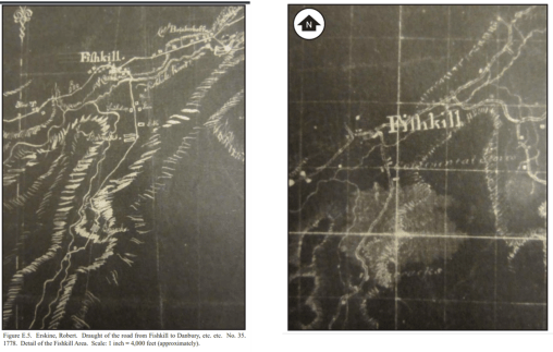
Fig 1. The two Colonial Cartographic renderings of the Region
Source: Richard W. Hunter, James S. Lee. A Historical and Archeological Synthesis of the Fishkill Supply Depot. Town of Fishkill, Dutchess County, New York. Hunter Research, Grant # GA-2287-14-00, published March 2016. Original maps contained in this review: Figure E.5. Erskine, Robert. Draught of the road from Fishkill to Danbury, etc. etc. No. 35. 1778. Detail of the Fishkill Area; Figure E.6. Erskine, Robert. A General Contraction. No. 37. 1778. Detail of the Fishkill Area. Scale: 1 inch = 4,600 feet (approximately)
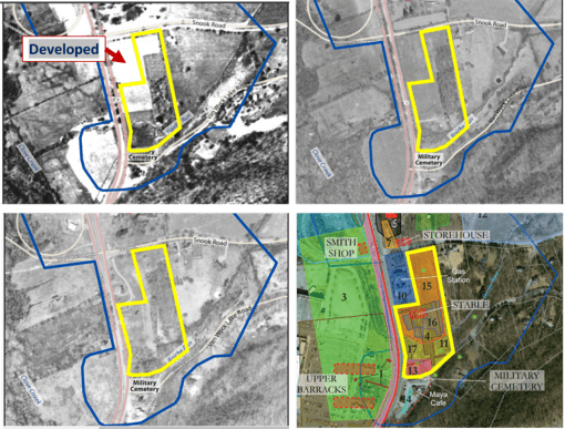
Fig 2. Three stages of Land Use Development in the Fishkill Encampment region – 1936, 1955, 1970
Source: Richard W. Hunter, James S. Lee. A Historical and Archeological Synthesis of the Fishkill Supply Depot. Town of Fishkill, Dutchess County, New York. Hunter Research, Grant # GA-2287-14-00, published March 2016.
NOTE: These different renderings of the site in Question – Area 11—are derived from figures contained in the Review of this site, published as Richard W. Hunter, James S. Lee. A Historical and Archeological Synthesis of the Fishkill Supply Depot. Town of Fishkill, Dutchess County, New York. Hunter Research, Grant # GA-2287-14-00, published March 2016.

Fig 3. Area 11 (yellow box) laid over two maps of the encampment, and an aerial image of part of Fishkill
Source: Richard W. Hunter, James S. Lee. A Historical and Archeological Synthesis of the Fishkill Supply Depot. Town of Fishkill, Dutchess County, New York. Hunter Research, Grant # GA-2287-14-00, published March 2016.
NOTE: The above two maps are of the encampment site; the lower two maps are aerial photograph derived reviews of the setting. For the upper two maps, Area 11 is estimated based on topographic or surface features. Original Sources: Hunter & Lee, page 2-8 : Figure 2.1. Erskine, Robert. Draught of the road from Fishkill to Danbury, etc. etc. No. 35. 1778. Detail of the Fishkill area (core area of supply depot circled). Scale: 1 inch = 3,800 feet (approximately); page 2-9: Figure 2.2. Ferguson, Patrick. [Part of the modern counties of Dutchess, Putnam, and Westchester {Version 1}]. 1778. Detail of the Fishkill area (core area of supply depot circled). Scale: 1 inch = 1
mile (approximately).

Fig. 4 The two early maps of Fishkill, with area 11 plotted over them to demonstrate topographic relationships (Row 1) and estimation of the possible level region used for burials, extending from the “Stable” to the located hillsides located east of the “Stable”
Source: Richard W. Hunter, James S. Lee. A Historical and Archeological Synthesis of the Fishkill Supply Depot. Town of Fishkill, Dutchess County, New York. Hunter Research, Grant # GA-2287-14-00, published March 2016.
NOTE: Red Area = Research Area for burials. Sources of these subsections of map are derived from the following figures in Hunter and Lee: Figure E.5. Erskine, Robert. Draught of the road from Fishkill to Danbury, etc. etc. No. 35. 1778. Detail of the Fishkill Area; Figure E.6. Erskine, Robert. A General Contraction. No. 37. 1778. Detail of the Fishkill Area. Scale: 1 inch = 4,600 feet (approximately)
