There are two important historical epidemics to note that are very similar to Ebola.  The first took place in 1816 along the Zaire/Conga River.  The second along the Niger River where it connects with Tschadda.  These are both epidemics that began with fever outbreaks, but which led to a high fatality rate and had symptoms that demonstrate a unique form of internal organs deterioration that other fever epidemics do not normally present with.  Fewer cases demonstrated the internal blood mass formations seen in the more contemporary outbreaks.  The most resemblance between these two outbreaks are their dates of initiation, days until fever symptoms, speed of spread to their others in the teams, and time until death.  Both were also colloquially termed “River Fever”  These support my premise that the Ebola and some  similar diseases have been around since they were first noted by the Portuguese missionaries in the 1690s.  Both of these overlap with the geographic distribution that we currently are familiar with, and are consistent with the topography, ecology and human population features determining how this disease may be spread.

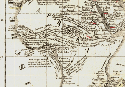
In a related posting, I provided the map depicting German medical cartographer Friedrich Schnurrer’s interpretation of what he learned about the Congo River epidemic documented by a Portuguese missionary leader   Fr. Anton Zuchelli (1696).  (see      https://brianaltonenmph.com/2014/10/14/is-there-an-early-history-for-ebola-preliminary-review-says-yes/  )

The following are the notes contained in reviews of the two writings pertaining to the above mentioned Ebola-like experiences.

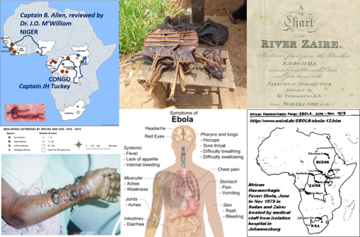
CAPTAIN JAMES HINGSTON TUCKEY, 1816

The first is regarding the September to October 1816 Congo or African Fever epidemic experienced by Captain James Hingston [Kingston] Tuckey:

[QUOTE]

“The crew consisted of eight petty officers, six artificers, fourteen able seamen, a serjeant, a corporal and twelve privates of marines making in all fifty six persons, of whom twenty one were doomed never to return. ‘Never’, says the editor, ‘was an expedition of discovery sent out with more flattering hopes of success, yet, by a fatality almost inexplicable, never were the results of an expedition more melancholy and disastrous.’ Captain Tuckey Lieutenant Hawkey Mr Eyre (purser) and ten (eleven) of the Congo’s crew — Professor Smith, Mr Cranch, Mr Tudor, and Mr Galwey, (a volunteer), in all eighteen persons, died in the short space of three months! Two had died in the passage outwards and the serjeant of marines survived only till the vessels reached Bahia.”

[END QUOTE]

Note:  Captain Tuckey was taken ill September 17, died October 4, 1816.

Source:  Art IV. Narrative of an Expedition to explore the River Zaire usually called the Congo in South Africa in 1816 under the Direction of Captain JH Tuckey . . . to which are added, the Journal of Professor Smith, some General Observations on the Country and its Inhabitants, and an Appendix containing the Natural History of that Part of the Kingdom of Congo through which the Zaire flows. Published by permission of the Lords Commissioners of the Admiralty 4to London 1818.  Book review in ‘The Quarterly review (London)’, January 1818.  See http://books.google.com/books?id=y3i1-YybvCAC&pg=PA335 

***************************************************

CAPTAIN B. ALLEN, 1841

This is regarding the Deaths from September to October 1841, at the confluence of the Niger and Tchadda, where Captain B. Allen and the crew were heavily infected, one third deceased, reviewed by Dr. J.O. McWilliam [M’William].

[QUOTE]

“Of the one hundred and forty five white men, only fifteen escaped the river fever; while of the one hundred and fifty-eight blacks, only eleven were attacked. The number of deaths is not clearly shown; but what from fever and other casualties, the tables appended show a total of fifty-three, among whom were Captain B. Allen, Lieutenant Stenhouse, Dr. Vogel, Mr. Kingdon, Mr. Willie. Mr. Wilmett, and two of the assistant surgeons.”

[END QUOTE]

Source:  Chambers’ Edinburgh Journal, Volume 12, Sept. 9, 1843.
http://books.google.com/books?id=G7MaAQAAMAAJ&pg=PA265

(Note: this Ebola is not as deadly as the current).

For the next several years, “Niger Fever” was a terms used to defines these unique cases presenting along the Niger.   Eleven major publications refer to this term for the diagnosis,, including The Lancet, British and Foreign Medical Review or Quarterly, Medico-Chirurgical review, and Edinburgh Med Surg Jl.  It is also contained in Robley Dunglison’s 185 Medical Lexicon.  See also John Forbes (ed.) book review in Brit. For. Med. Rev. Q., July 1843, at http://books.google.com/books?id=B_AEAAAAQAAJ&pg=PA259&nbsp😉

Supporting documents for these fevers being quite different from yellow fever, malaria, and numerous other more common fevers are contained in McWilliam’s Autopsy notes, details of which were published in his book and as part of the combined book review found in the Edinburgh Med. Surg Jl., 1845, v 63).   Link:     http://books.google.com/books?id=t_8aAQAAMAAJ&pg=PA432 ;  another version http://books.google.com/books?id=-Vo9AQAAMAAJ&pg=PA392

See on Scoop.itMedical GIS Guide

A section of the first disease map of the world.  From Friedrich Schnurrer’s ‘Charte über die geographische Ausbreitung der Krankheiten: vorgelegt der Versammlung Deutscher Aerzte und Naturforscher zu München’, Published 1827.  

In 1827, Friedrich Schnurrer’s ‘Charte Uber die geographische Ausbreitung der Krankheiten’ was published detailing his summary of diseases around the world.  Schnurrer wasn’t the first to study disease patterns globally, he was simply the first to place all of his notes on the world diseases and epidemics he know and read about onto a single map.  


One of the earliest essays on disease and place, in terms of the planet, was the work of Johanne Christophor Homann, with his Medicinae Cum Geosophia Nexu [the Medical-Geography Connection], 1720.  (see my page – http://wp.me/Puh6r-7MS&nbsp😉


The next massive tome published on disease patterns was by the famous author and printer of a very young United States, Noah Webster, who wrote a compendium on the history of the outbreaks around the world, all in an attempt to define geographic and climatic reasons for their recurrences (link below).  His book served to explain how and why the United States was experiencing numerous, deadly yellow fever epidemics, which were referred to as the "black plague" at the turn of the century.  Webster’s have a natural explanation for all of these events ensuing around the world, blaming the diseases on volcanoes, massive storm patterns, earthquakes, increased global heating by the sun, and yes, environmental and climate change (for a review of Webster’s theory of weather change patterns, deforestation, and climate change, see: Deforestation and Global Cooling: A New Theory for Disease by Noah Webster, 1810, at http://wp.me/Puh6r-3JA (2012); and http://www.smithsonianmag.com/ist/?next=/history/americas-first-great-global-warming-debate-31911494/ (2011)).


in 1813, Schnurrer wrote ‘Geographische Nosologie oder di lehre von den Veränderungen der Krankheiten’ , that is to say, with brevity, knowing the geography of certain disease types.


which set the stage for his next important publication, the map of world diseases published in the 1828 Das Auslan (full citation with link to scanned copy at the end).  


My purpose for reviewing this map and Schnurrer’s earlier work was to determine if there was any evidence for Ebola found on the map, and/or in the earlier writings by Schnurrer on the global disease patterns documented in explorers’, settlers’ and travelers’ writings. 


The way Schnurrer and others for the time defined disease patterns was by their place of natural existence, known as the nest or nidus for a disease, and by their placement on the earth in relation to its latitudinal patterns, used to describe airflow and climate, the weather associated with the disease patterns documented for the time, and the local topography and natural ecological settings that the authors linked to these disease pattern observations.


Only the map will be reviewed for the moment.  


The current behavior of Ebola shows that it is staying north of the equatorial line.  If we review the diseases of this region, we find thirty nine distinct disease descriptions given for illnesses common to Africa between 0 and 30 degrees north.  That part of African between the 0 and 20 degrees latitude line is for the most part equatorial in nature.  Two attacks of "pestilence" are noted in this "torrid" or tropical zone (as later medical geographers referred to it), one epidemic each for the years 1696 and 1811.  Since both of these are along the eastern end of upper Africa, they are rule out as Ebola possible ebola events for now, even without reviewing their symptomatology .   


Throughout the north torrid region, there are numerous disease types defined symptomatically by Schnurrer as fevers, bearing the word fiber in their categorical name assignments ("Fieber", abbrev. as "Fieb.", "f" or "F.").  The Pox is also noted ("Poken", with a brief reference to the "Quarantaine" performed).   Numerous forms of venereal disease are displayed (abbrev. "v.d." or identified by their namesakes–syphilis and gonorrhea).  


To differentiate the large number of fevers that appear on this map, the related symptoms noted are helpful.  Galliche Fieber is yellow fever, that by Senegal is "common to the Negroes. . . ).   Galliche rem[ittent] fever is possibly yellow fever, but also possibly malaria (remittence refers to cycling).  A number of intestinal worm or "animalcule" diseases are also worth noting ("Faden ~~").


Just south of the equator is Gangran des Mastdarms nach heftigen Kopf u. lenden schmerzen Berriberri (Zuchelli).  It is displayed along and south of the Congo River.  From its name we know that it could be called the "Gangrene de Mastarms", a necrosis or gangrene of the entire intestinal tract commonly linked to some form of diphtheria by the late 1800s (see Semple, 1879).  The descriptive portion of this disease name is "hestigen Kopf u Lenden schmerzen Berriberri", which translates to  "vehement head & lumbar pain beriberi", the last section implying an appearance of beriberi–appearing cyanotic and about to die.  (see http://renovatingyourmind.com/2013/03/25/renovating-your-minds-makes-a-social-call-to-the-first-member-of-the-b-complex-family-b1-thiamine/beriberi-alcoholism-thiamine1-deficiency/&nbsp😉


This is possibly the first documentation of Ebola as a disease native to the Congo River on a map, by Missionary Father Antonio Zuchella in 1696 (Benicken, 1824), in what it now the DR Congo.


*******************************************************


REFERENCES (if not in the above text).


A BRIEF HISTORY OF EPIDEMIC AND PESTILENTIAL  DISEASES  ;  WITH THE PRINCIPAL PHENOMENA OF THE PHYSICAL WORLD, WHICH PRECEDE AND ACCOMPANY THEM, AND OBSERVATIONS DEDUCED FROM THE FACTS STATED. IN TWO VOLUMES. BY NOAH WEBSTER, 

At http://english.byu.edu/facultysyllabi/KLawrence/WEBSTER.briefhistory.pdf 


Geographische Nosologie oder die Lehre von den Veränderungen der Krankheiten   … 1813.  By Friedrich Schnurrer.  http://books.google.com/books?id=W84UWCIi3qMC 


1824. Das Auslan. Ein Tagblatt fur Kunde des geistigen und sittlichen Lebens der Volker mit besonderer Rucksicht auf verwandte Erscheinungen in Deutschland. Erster Jahrgang. Bd. 1-2. Munchen der Literarisch-Artistischen Anstalt der J. G. Cotta’schen Buchhandlung. 1828 / / 

Der Verleger Johann Friedrich Cotta …, Volume 1, Issues 1787-1814, 
edited by Deutsches Literaturarchiv / / 

Nr. 90, volume 30. 22 Sept 1827, S. 357-359. Die geographische Vertheilung der Krankheiten, vorgelsesen in der Versammlung Deutscher Aertze und naturfirscher zu Munschen den 22 Sept 1827 (S. 3570359). Charte uber die Georgraphische Ausbreitung der Krankheiten von Frid. Schnirrer Med. Doc. Vorgelegt der Versammlung Deutscher und Naturfischer zu Munchen den 22 September 27. Lithographie. 1 gefalt. Bl. 2).  

Title:  Charte über die geographische Ausbreitung der Krankheiten: vorgelegt der Versammlung Deutscher Aerzte und Naturforscher zu München 

The map is available for viewing and download at: 

http://archive.thulb.uni-jena.de/hisbest/receive/HisBest_cbu_00025637


Robert Hunter Semple.  1879.  On diphtheria
 http://books.google.com/books?id=5RkDAAAAQAAJ&pg=PA59 


Zeitrechnungs-Tafeln für den historischen Handatlas: Mit steter Rücksicht …

 By Friedrich Wilhelm Benicken . 1824.  

http://books.google.com/books?id=P7lRAAAAcAAJ&pg=PA135


Reference noted in the book (sic): "Deo Pater-Merolla Reife nach Congo. 1696. Der Miffionar Ant. Zuchelli bereifet Congo. – Die Portugifen werden vom Kuatenhandel verbrängt, behalten jedoeh Mazagan und die vier Guinea-Infeln."

See on Scoop.itMedical GIS Guide

Poughkeepsie Journal (Hudson River Valley, NY), 1797 (from the microfilm collection at Adriance Library, Poughkeepsie, NY).  


Yellow Fever invades Philadelphia.


This small item published in the Poughkeepsie Journal is the tale of what happened in Philadelphia, when the yellow fever struck it in 1797.  40,000 people fled the city in just days.  Once more ships infected with yellow fever struck New York, just as many fled the streets of its greatest city, finding refuse upstream and in the more rural settings of the Hudson River Valley in New York. According to the weekly reports that appeared in the papers about either of these disease outbreaks, deaths climbed from the hundreds to the thousands in a very short time.  


Much the same is happening right now or readying to take place for Ebola.  The article this image links to details how to deal with a global epidemic catastrophe ‘in just five steps.’

Source: www.vox.com

To understand human behavior during an epidemic, we need only turn to American history.  When yellow fever came to Philadelphia in 1797, deaths were in the thousands per week by the time the outbreak peaked within the urban proper.  Many of these deaths occurred at home or in the Almshouses. Much of this news was published by the weekly newspaper of the Hudson River Valley, the Poughkeepsie Journal, the major newspaper for lower New York State along the Hudson River Valley.  


According to this brief report, in just a few days to weeks, the City of Philadelphia experienced 40,000 departures as the residents left surviving escaped from the core of the city, creating congestion along the way as they relied upon local merchant ships and wagoneers to make their way to safe haven.  


At times, these passengers unknowingly brought the disease with them, or at least the means for infecting the next mosquito vector that consumed their blood before making its way to the next victim(s).  In this way, the yellow fever managed to spread from one town to the next, one city to the next, one poor neighborhood to the next, whether it be from hamlet to city, shipping port to shipping port, port city to countryside.  


The late 1790s yellow fever epidemic and the one or two that recurred later were all it took for doctors at medical schools in New York, and Philadelphia to implement and succeed in producing the first effective quarantine practice.  In New York City, they relied on the islands just outside New York City, in the harbor and adjacent riverways.    


These quarantine practices were put to the test over the next decade or two.  In the 1830s, they were no longer that effective when the next major epidemic made its way to the United States.  The famous Asiatic cholera, originating from large ports in India, made a brief stay in the U.S. in 1832.  In winter of 1848/1849, it began are more aggressive importation in February from India to the Mississippi River delta, just before the Gold Rush in lower California began.  


Since the Gold Rush pioneers were mostly boys and men, they did not bring the cholera with them westward as much as the later pioneers would do.  Re-emerging in Spring of 1850, and again in 1852, between April 15th and May 30th for each of these years, the experiences of the large numbers of deaths due to cholera were penned in Oregon trail diaries.  


Just west of Fort Kearney, these Oregon Trail pioneers wrote about the deaths that ensued following their brief stay at Fort Kearney, where thousands of people moved about on a busy day.   Departing Fort Kearney, they penned their experiences and observations and they witnessed dozens of people taken ill by the disease, many dying, except for young men and young boys.  


The reason for these "hot spots" west of the Fort were several.  Climate, distance travelled, close contact and population density were perfect for making this outbreak happen.  With each death, the remains left behind found new victims passing through.  It ended up, the environment was perfect for maintaining a steady culture of Vibrio cholerae within the alkaline waters filling freshly dug drinking wells.  "Dig your own well" was the saying for the time.


This outbreak was more deadly than any other diarrhea like contagious disease for the time, including the most likely dysentery to strike the people in Nebraska at this time.  Until vibrio came upon to the plains, a Salmonella intermedia (and perhaps Listeria) growing upon the rotting flesh of bisons was known to cause severe diarrhea.  For the pioneers, those who made it past Fort Kearney and a similar outbreak next to Fort Laramie, Wyoming, were often put at risk by the decaying carcasses of oxen and cattle that died while trying to ascend the eastern face of the Rockies.  (See my thesis page on this research, for more detail, at http://oregontrailcholera.wordpress.com/  .)


When an outbreak happens. human behavior becomes difficult to manage, almost impossible to control or predict.  If the Ebola outbreak were to reach the U.S., and if its severity were to reach the level that cholera reached during the 1850s, what we should expect to see is a disease that spreads like "wildfire" (taken from the Andromeda Strain).  The diffusion would be from neighborhood to neighborhood, one population setting to another, in a heterogenous, mixed radial-hierarchical diffusion process (using Gordon Pyle’s sense of the words, see https://brianaltonenmph.com/gis/historical-disease-maps/john-c-peters-and-the-asiatic-cholera/1960-pyles-cholera-diffusion-and-migration-patterns/ ).  


By keeping a close watch on this outbreak–were it to happen (I am trying to be rational about this)–spatial epidemiologists would no doubt have a very unique opportunity to map one of the most aggressive epidemics to take hold of its victims in fairly short time.  Due to its incubation time, this Ebola would always be a little ahead of them, by two or three weeks.  


My proposal is that this disease (see my July 7th ScoopIt!, personalblog, and map image: https://wordpress.com/post/7215587/41081 ), is that it will follow a dual path mathematically (nature’s common practical joke on us).  It will be opportunistic and appear very deterministic in its earliest habits, but demonstrate the more complex migration patterns (Pyle’s mixed models) as time passes for each setting;  transportation helps to define these stochastic (chaos theory) behavior of the disease, and will ultimately define whenever and where ever the Ebola decides to travel to next.  All of this makes prediction modeling a much tougher process.  The most likely routes, based on natural ecology, not human ecological impacts, are noted on this map.


It is important to note here that Ebola is a viral disease, not be spread by airborn vectors like the mosquito born yellow fever or more recent west nile (that is for not, it is not airborn).  Still, Ebola is more deadly than the west nile and yellow fever.  In terms of appearances, it may be as bad as or worse than the looks of the yellow fever and cholera victims during their dying hours.


But more importantly, Ebola is different from Yellow Fever and Cholera because it has a more distinctly landborn element as part of its natural ecology.  


Vibrio cholerae remain alive in deltaic brackish saline water, are dependent upon copepods, and from there enter into the higher animal portions of the food chain or web.  West Nile survives the winter due to its hibernation in surviving female mosquito bodies not destroyed by the coldness of winter, able to arise and infect their first animal or human victim of the year.


The spatial limits for each of these are the chemistry and zooecology of the aquatic environment, and the need for the right climate and water.  


Ebola lacks these restrictions to aquatic and shoreline settings.  Yet it still bears some other features of its own, that may even be foretelling.  


Ebolavirus can remain alive on land where certain mammals reside.  Its ability to survive within a supporting ecosystem, without incidence of human involvement, is very much possible.  Even in distant places, Ebola can reside for a considerable length of time, undetectable and unpredictable by contemporary surveillance programs.  Regions that are poorly managed, poorly funded, and otherwise forced to live with underfunded health surveillance programs are going to be the most impacted by this disease.  They also bear the population most at risk due to sanitation problems, their social disconnect, and their problematic lifestyles.  Regions that are rich in domestic and wild animal populations but lacking adequate disease surveillance programs for zoonotic diseases, are where this disease could most likely have its greatest impact on local public health.  


So can we really afford to prevent a disease like Ebola?  much less stop it in its tracks should it become an ecological phenomenon.


Due to the mobility of its hosts and carriers (mammals, esp. frugivorous bats), Ebola is capable of migrating where ever it needs to, given enough time and new victims.  It may not even be an immediate human threat, until its finds the right human ecological setting to establish its new domain.  According to the research of its hosts, carriers, vectors, zoonosis ecology, there are specific regions that exist, each with its own outbreak and nidus development potentials.  The way to define these regions and what the Russian geographer call their ‘metaxenotic potential’ and combined host-human spatial region, is defined by the works of Voronov and Pavlovsky. ( https://brianaltonenmph.com/gis/historical-disease-maps/zoonoses/ &nbsp😉

See on Scoop.itMedical GIS Guide

https://www.youtube.com/v/Yb4P_QM-Rjc?fs=1&hl=fr_FR

http://youtu.be/Yb4P_QM-Rjc IMG 1275 AFRICA

Source: www.youtube.com

I did these studies years ago about African health history, disease patterns, linked human behaviors, genetic, and culturally-bound disease patterns into the US.     


I broke down the African cultures in-migrating into the slavery era defined, post slavery and predominantly Muslim related in-migration periods.  These ICDs related to African heritage were then  reclassed into those groups,  and about 180 definitive ICDs for African influence defined.     


This 3D rotating map is one of the first I produced depicting my study results.  It was used to demonstrate the value of the Remote Sensing equations when applied to grid modeling techniques, the mathematical method I designed for implementing this detailed US epidemiological surveillance technique.   


Other examples of my cultural ICD 3D mapping studies are at [Topic: Inmigrating Disease Patterns]     https://www.youtube.com/watch?v=zQ60npQzdTk&list=PLWrApErk5bybFfsOWTXWjlwvIM7D4d6-h    


The primary, secondary and tertiary mapping developed begins with the basic in-migration patterns, followed by cultural-behavioral and then genetic diseases, all identified based upon ICDs.   


This Youtube site is also rich in sociological, zoonotic, genetic, V-code and numerous other foreign born and/or re-emerging disease patterns that I developed NPHGs for.   


See: https://www.youtube.com/watch?v=dSP6tOQs-RQ&list=PLWrApErk5byZnE0bWUqdfH4CYVmnETLg6    


My REGIONS & HEALTH pages provide specific applications for these techniques.  The Pacific Northwest issue for example was detailed and discussed extensively a few years ago, beginning with    


Regional Health Planning and the Pacific Northwest Medical GIS and Regions series    

http://wp.me/Puh6r-7TZ    


I posted hundreds of examples of the 3D mapping in this series, 

with GIS applied specific to Pacific NW issues on the page at     http://wp.me/Puh6r-8l2    

See on Scoop.itNational Population Health Grid

CDC Confirms First Ebola Case Diagnosed in U.S.

Source: abcnews.go.com

We can rationalize it as much as we want to, but it still happened. Now we are left with an opportunity to look at the exact number of people possibly in direct, indirect and atmospheric to inferred indirect contact. Directly and indirectly infected places versus infected people can be documented. Right now it is only a case that is a loner within the lone star state. It is not how many cases there have been and how many of these were fatal that matters so much any more. The question might do become what stage in that exponential growth curve are we in? and what is the doubling time? Right now we are in the first stage of disease ecological development in a spatial diffusion process. Pure spatial features defining this outbreak make it a radial event to imagine. Hierarchical human diffusion pattern make us worry about whether there is (will be or could be) a direct flow of the contagion between airports impacting other latitudes in the US, or might it be restricted mostly to intrastate patterns? Due to incubation times, we may now have to wait two or three weeks to find out. Fortunately, seasonal climate changes are on our side, since the cooler months of winter are approaching in Texas. Geography and climate are in favor of the outbreak for the next month or two spatially. The lack of US engagement in this crisis several months ago means we are directly responsible for our own fate at this point. There was no reason or logic for our failure to engage in appropriate preventive health care practices two to three months ago. The outbreak status here has moved from prevention to containment stage. By now, if we are fully prepared in Atlanta, transportation analysts should know the flow patterns in and around this new potential nidus–by air, land and even water. If not, we’ve been caught with our guards down. By tomorrow we’d better know how a potential host-vector relationship might develop. Even once human cases are fully contained, an animal born ecological nidus can still develop. An eastward, northeastward flow pattern out of Texas is therefore favored. But I am really just looking at worst scenarios here. Let’s hope this Texas case remains on its own turf and hospital bed in the Lone Star state. History show us that it is nearly impossible to prevent foreign born diseases from coming to the U.S. We can delay entry, but if ecology is in favor of transmission and human behavior remains the same, nature simply waits until we let our guards down again. When it comes to man versus nature, we may first win out spatially. However, temporally, nature is not on our side.

See on Scoop.itMedical GIS Guide

As in Bubonic Plague, carried by various mammals, esp. prairie dogs in the western and southwestern U.S. Associated with flea vectors. Pest: Yersinia pestis….

Source: www.youtube.com

Geographically, you’d expect the plague to be western-bound.  But significant numbers of cases are reported all over the United States since 2010.  


The east coast peaks in cases demonstrate something unexpected about this diseases.  Historically, we think of it as the great bubonic plague, once gone awry but now under considerable control.  In the U.S., we often learn about the association of the plague with prairie dogs.  Since the flea is its vector, you need only be near a prairie dog colony to potentially be exposed to this organism.  (Not great news for us Western field epidemiologists out there dealing with other zoonotic diseases.)


But the matching high peaks along the west coast points to population density as well influencing where the cases are reported.  This should be no surprise, since peoples’ presence is needed for human cases to be developed, and then later reported.


So initially, this map tells us that the plague could be transmitted by many other diseases, in both natural and human ecological manners, and unfortunately bearing reasons for its potential urban impacts that in some ways are very different from why and how it becomes a rural epidemiological event.


However, people travel, and in-migration routes makes their way to the heavily populated ports for international shipping.  


Is latitude a feature in how and where an imported case of the plague might enter the U.S.?  Perhaps, since climate does impact both vector and host activity patterns and willingness to travel or change both animal and environmental settings.


Population density is more a concern for international spread of Yersinia pestis should some new, resistant strain emerge.  


Is the Pacific Rim a route of travel to consider?  If you ask a west coast public health economist or epidemiologist, most certainly.


Still much of the commercial travel from the Orient follows traditional routes, and the more heavily, most heavily populated regions of the east coast are very likely to produce some of the first cases if their origins were abroad.  


This leaves only a single isolated peak in the midwest to be better understood.

The ratio of Mosquito diseases, like Chikungunya, to Primate hosted diseases like Ebola, is 700:1 (rounding Ebola cases to 500 total).  yet the fatality of Ebola is so horrendous, visual and high in terms of percentages, that we focus much more on the Ebola outbreak than we do a disease creeping into our ecology slowly by means of ongoing host-vector behaviors.  There are other diseases that penetrated the ecology of North America even more slowly that those which are mosquito borne.  


Source: m.yahoo.com

The very slow migrating tick borne diseases such as lyme disease remains a very important public health issue, but its victims remain uncounted by most news writers. Lyme disease victims do have their issues you know.


See:

1. Lyme Victims from Around US to Gather at IDSA Headquarters and Demand Changes to Guidelines for Lyme
Thursday, 15 May 2014. http://truth-out.org/speakout/item/23732-lyme-victims-from-around-us-to-gather-at-idsa-headquarters-and-demand-changes-to-guidelines-for-lyme 

2. Views: Give Lyme victims same rights as other patients
Holly Ahern. Poughkeepsie Journal. http://www.poughkeepsiejournal.com/story/opinion/valley-views/2014/06/14/lyme-disease-patients-chronic/10533911/?from=global&sessionKey=&autologin= 


In August 2013 it was estimated by CDC that about 300,000 new lyme disease cases are identified each year (as many as twice of much are estimated however due to underreporting; CDC. http://www.cdc.gov/media/releases/2013/p0819-lyme-disease.html) .


If the same holds true for 2014, that means the ratio of the three diseases so far discussed are 700:600:1, for Chikungunya:Lyme:Ebola.  [For CDC info page on Lyme, see http://www.lymediseaseassociation.org/index.php/resources/cases-a-other-statistics ]


Not add to this west nile cases, which are incredibly scarce.  So far, perhaps <50 in the U.S., but it is still quite early.   (see http://www.cdc.gov/westnile/statsMaps/preliminaryMapsData/&nbsp; and July 8 data– http://www.cdc.gov/westnile/statsMaps/preliminaryMapsData/histatedate.html &nbsp😉


Still in spite of all of these significant number differences, the public is in general most reactive to Ebola, because it is so deadly (30-50%), and because there’s that expectation for what might happen.  


West Nile is deadly too, but mostly to elders and children and those of a weak immune system or "constitution", and even so, deaths are infrequent to rare.  There are no deaths as of yet in the U.S. due to Ebola, but such a case would take center stage if it were ever to happen.  Lyme disease we’ve grown adjusted to.  Chikungunya we’ve also got our eyes upon.  


SO WHAT HAVE WE FORGOTTEN?  


Anthrax, Arboviral diseases, neuroinvasive and nonneuroinvasive, 
Powassan virus, Cholera, Dengue Virus Infection, Dengue fever, Dengue hemorrhagic fever, Dengue shock syndrome, 
Hansen disease (leprosy), Malaria, Plague, Poliomyelitis – paralytic
Poliovirus infection – nonparalytic, Psittacosis, Q fever, Severe acute respiratory syndrome-associated coronavirus (SARS-CoV) disease, Omsk Fever, Russian Tick Disease(s), Shiga toxin-producing (STEC), Shigellosis, Trichinellosis, Tuberculosis, Tularemia, Typhoid fever, Vibriosis, Viral hemorrhagic fevers, New World Arenavirus, Crimean-Congo hemorrhagic fever virus, Ebola virus, Lassa virus, Marburg virus, Yellow fever, and dozens more which we can’t immediately recall the names of.


SEE:


My "Foreign Disease Intrusion" list (no NPHG video links) at https://brianaltonenmph.com/gis/global-health-mapping/foreign-disease-intrusion/&nbsp;


National Institute of Allergy and Infectious Diseases.  Emerging and Re-emerging Infectious Diseases. http://www.niaid.nih.gov/topics/emerging/Pages/list.aspx and  http://www.niaid.nih.gov/topics/emerging/Pages/Default.aspx


Deborah A. Adams, Kathleen M. Gallagher, Ruth Ann Jajosky, et al.  (2012).  Summary of Notifiable Diseases — United States, 2010.  MMWR.  June 1, 2012 / 59(53);1-111 

http://www.cdc.gov/mmwr/preview/mmwrhtml/mm5953a1.htm


Ronald Barrett, Christopher W. Kuzawa, Thomas McDade, and

George J. Armelagos.  (1998).  EMERGING AND RE-EMERGING
INFECTIOUS DISEASES: The Third Epidemiologic Transition.  Annu. Rev. Anthropol. 1998. 27:247–71.  http://epa.gov/ncer/biodiversity/pubs/ann_vol27_247.pdf&nbsp;   


Brian D. Gushulak, and Douglas W. MacPherson.  Globalization of Infectious Diseases: The Impact of Migration

Clin Infect Dis. (2004) 38 (12): 1742-1748.  doi: 10.1086/421268   

http://cid.oxfordjournals.org/content/38/12/1742.full&nbsp;


Manny Alvarez.  July 7, 2014.  Dr. Manny: Is America on the verge of a major health crisis?  http://www.foxnews.com/health/2014/07/07/dr-manny-is-america-on-verge-major-health-crisis-985339470/&nbsp;


Cal Thomas.  (July 8, 2014).  Immigration crisis: Our Constitution doesn’t guarantee entry to the United States.   

http://www.foxnews.com/opinion/2014/07/08/immigration-crisis-our-constitution-doesnt-guarantee-entry-to-united-states/&nbsp;


The concerns about IN-MIGRATING DISEASE PATTERNS are reviewed in the following reports:  


Robbie J. Totten.  Contagious Disease, Epidemics, National Security, and U.S. Immigration.  CDC, 2012.  Historical Policy Responses.  

http://ccis.ucsd.edu/wp-content/uploads/Robbie-J-Totten_Epidemics-and-U-S-Immigration-Policy-2.pdf


Association of State and Territorial Health Officials . (2013).  Global Infectious Disease Impact on State and Territorial Health.  

ASTHO Global Health Meeting, July 31, 2013, Washington, DC.  http://www.astho.org/Programs/Infectious-Disease/Refugee-Health/Global-Infectious-Disease—Impact-on-State-and-Territorial-Health/&nbsp;


Ruth Ellen Wasem.  Specialist in Immigration Policy, Congressional Research Service.   April 28, 2014.  Immigration Policies and Issues on Health-Related Grounds for Exclusion.   

 http://fas.org/sgp/crs/homesec/R40570.pdf &nbsp;


Other MEDICO-POLITICAL NEWS regarding disease patterns and immigration:


Immigration Issues. Illegal Immigration and Public Health (2009)   http://www.fairus.org/issue/illegal-immigration-and-public-health


PolitiFact Texas.  Dan Patrick has called illegal immigration an invasion and said immigrants bring ‘Third-World diseases’  http://www.politifact.com/texas/statements/2014/jun/20/battleground-texas/dan-patrick-has-called-illegal-immigration-invasio/


Marc Siegel.  Fox News.  Immigration crisis: US experiencing major public health crisis, too.  http://www.foxnews.com/opinion/2014/06/30/immigration-crisis-us-experiencing-major-public-health-crisis-too/&nbsp;

Ryan Lovelace.  William F. Buckley Group Fellow.  Texas Immigration Center a Magnet for Disease.  Border Patrol union says poor medical screening risks new virus outbreak. http://www.nationalreview.com/article/381101/texas-immigration-center-magnet-disease-ryan-lovelace &nbsp;


Laura Murphy.  The Guardian.  The Mexican ‘germ invasion’ is just the right’s latest anti-immigration myth.  http://www.theguardian.com/commentisfree/2014/jul/02/border-patrol-diseases-anti-immigration-myth [note: potential bias noted due to relation to missionary activities]


MY RESEARCH on this (one of several NPHG video sets of foreign born viral, vectored, hosted and/or zoonotic diseases, in YouTube:  

By diseases — https://www.youtube.com/playlist?list=PLWrApErk5byZnE0bWUqdfH4CYVmnETLg6&nbsp;

By regions or countries — https://www.youtube.com/watch?v=zQ60npQzdTk&list=PLWrApErk5bybFfsOWTXWjlwvIM7D4d6-h


“Doctors say they are concerned about false rumors and “hysteria” that the unaccompanied children coming across the border from Mexico into Texas are carrying diseases such as Ebola and dengue fever.”  


Source:  NBC News.  Maggie Fox. (dated July 9, 2014).  “Vectors or Victims? Docs Slam Rumors That Migrants Carry Disease”    http://www.nbcnews.com/storyline/immigration-border-crisis/vectors-or-victims-docs-slam-rumors-migrants-carry-disease-n152216


WELL WHAT ABOUT THE OTHERS.

Source: www.nbcnews.com

As is often the case, concerns, fear and even panic arise with some of the worst logic.   The fear may be right and have good reasons for its existence, but unless we consider the alternatives for how else it might apply, we could result in two series of negative historical epidemiology events–ignoring the original claim because it is misapplied, and missing the boat as how to better apply it.  


NPHG mapping doesn’t support the claim that in-migrating from Mexico and lower parts of the Americas  in unlikely to bring in diseases for us to be concerned with. 


Ecological fallacy is when you believe your observations and deductions pertain to a much larger area or population.  Such is the case for those arguing these "false rumors."


The support for the "possibility" (a term we should even consider removing from this sentence)  that in-migration patterns do not increase the risk of behaviors and disease coming in from other areas, peoples and culture is absurd.  We can try arguing the point that immunizable diseases is not a concern, because we can simply provide these as soon as they come in, although many underprivileged classes in this country also in need of these medicines will most certain fell neglected, and rightfully so.


The article is right in stating the concerns about dengue fever are overrated (see video), and my Ebola work is appearing to show that this is also unlikely to be linked to Mexico in-migration, as much as Caribbean or Natural Animal in-migrating patterns.


The argument that sufficient quarantine and public health monitoring strategies are in place only holds for those who enter this country legally.  


The real indicators here are the presence of in-migrated diseases from countries to the south, such as the most obscurest of ICDs with a well-defined cultural relationship–Chiclero’s Ear and Pinta.


But we can add more to this if need be.  Vibrio cholera outbreaks from a strain bred in Peru, Brazilian blastomycosis, and venezuelan encephalitis.


As I recently demonstrated on one of my ScoopIt! pages about Ebola, the most likely route of entry naturally is via the Caribbean and/or South to Central American route, through the eastern Texas-Mexico border, directed Northnortheastward.  The human in-migration route, more likely, involves major airports from Africa.


See:


Dengue, at https://www.youtube.com/watch?v=eHyehbfOwFo&nbsp;


El Tor cholera at https://www.youtube.com/watch?v=m5tccQopKFE&nbsp;(demonstrates a nidus in the NYC area, due to rule outs and high density of cases, but the major localized cluster in the Southwest)


Brazilian Blastomycosis, https://www.youtube.com/watch?v=bPgOWoC1lO8


Chiclero’s Ear (route very strongly demonstrated), https://www.youtube.com/watch?v=BmLlfLze1Lo


Pinta, using an earlier and very unique presentation technique, at https://www.youtube.com/watch?v=KCTueptEHlc


Venezuelan Encephalitis, https://www.youtube.com/watch?v=iuKuvqAlZFU


Disease distributions in the US for ICDs linked to Middle and South America, https://www.youtube.com/watch?v=dk7z6dbGuj8


My coverage of the disease in-migration for numerous parts of the world: https://www.youtube.com/watch?v=zQ60npQzdTk&list=PLWrApErk5bybFfsOWTXWjlwvIM7D4d6-h


There have been 48 confirmed cases of the mosquito-borne illness in Florida.

Source: www.wtsp.com

This pattern is behaving very predictably, based on yellow fever behaviors documented since 1797, and some of the vibrio cholera patterns in U.S. soil since 1832.   There is a northward transgression of mosquito born diseases (for obvious reasons).   As documented in some west nile work from 2000-2005, ecological methods may be used to predict ecosystems most likely to harbor the species that serve as the most active vectors.  (see my canopy light penetration field work for starters – at https://brianaltonenmph.com/west-nile/west-nile-surveillance-2/&nbsp;).


Further comparing vibrio and chikungunya, vibrio is water dependent and ecologically bound to it deltaic settings (i.e. New Orleans and Galveston area–though some will dispute me about this), and is fully dependent upon isopods.  On the other hand, chikungunya behaves according to mosquito patterns much like the yellow fever and dengue, and lacks the stricter peri- and subaquatic requirements.  


My standards for performing mosquito vector disease ecology research as a small area GIS study are provided at https://brianaltonenmph.com/west-nile/west-nile-surveillance-2/


Remote sensing methodologies are reviewed in detail at https://brianaltonenmph.com/west-nile/6-remote-sensing/&nbsp;


The following outline begins at https://brianaltonenmph.com/west-nile/&nbsp;


 West Nile Surveillance – http://wp.me/Puh6r-rY&nbsp;  The Research Area  –  http://wp.me/Puh6r-sa&nbsp;  Vectors – http://wp.me/Puh6r-yJ&nbsp;  Assigning Risk – http://wp.me/Puh6r-sd&nbsp;  Host Surveillance – http://wp.me/Puh6r-sh&nbsp;  Vector Ecology and Surveillance – http://wp.me/Puh6r-su&nbsp;  Plant Ecology – http://wp.me/Puh6r-gL&nbsp;     Topography – http://wp.me/Puh6r-sq&nbsp;   NLCD Grid Mapping and West Nile – http://wp.me/Puh6r-sO  West Nile – Light Penetration Study – http://wp.me/Puh6r-gN&nbsp;  Remote Sensing – West Nile – http://wp.me/Puh6r-dH&nbsp;   Case-related Surveillance –  http://wp.me/Puh6r-sX&nbsp;


ENDNOTES:


Images from : Wikipedia, Florida and Polk County, MyFoxHurricane.com, National Park Service (Everglades project – “Lightscape / Night Sky” at http://www.nps.gov/ever/naturescience/lightscape.htm, and South Florida Aquatic Environments, at https://www.flmnh.ufl.edu/fish/southflorida/pisces.html

This set of maps can be reviewed in detail at


http://www.pinterest.com/pin/568790627911639938/


The Geography of Ebola, goes one step beyond the environmental ecological concept of Ebola patterns.  Past geographers had a unique way of evaluating disease long before the microbial (pre-bacterial) theory became popular in the mid-1870s.  Using some of these older methods of spatially reviewing disease behaviors, we discover some important insights worth pursuing as spatial epidemiologists.  Amongst these are spatial theories linked to density, diffusion processes and the natural history of disease over time as natural endemic or epidemic disease processes.


By 1800, the latitude theory for disease was already well established.  This identified certain regions close to the equator and hot, humid climates as most conducive to bad health (see  https://brianaltonenmph.com/gis/historical-medical-geography/1814-the-latitude-of-pestilence/&nbsp; ).  Matching the latitude theory was the longitude theory, which had its support as well in the form of diseases that remained in the Americas and failed to infect Europe, at least in the initial years.  The prime example of this was yellow fever during its first decade or two of infecting North American coastal cities (this are on the map is from Alexander Keith Johnston’s map, which I review extensively at https://brianaltonenmph.com/gis/historical-disease-maps/alexander-keith-johnston-health-disease/ &nbsp;).  Race and place of origin have also been linked to sickness, based on the argument of certain kinds of people being more “adapted” to specific settings.  The belief that climate and weather were related to diseases was as old as the study of medicine itself.  Adding to these early hypotheses by the mid-1800s were the ecological and natural history theories, based upon topography, soil, water, and unique features like slope and aspect (angle relative to the sun, for example for a mountain face).


20th century renderings of climate, weather, vegetation zones, and an areal feature known as the Köppen-Geiger climate classification system has become important in understanding global ecology. [for an original map see http://www.ie.unimelb.edu.au/research/water/hydroclimatology.html &nbsp;  ].  Understanding global ecology is important to understanding the geography of Ebola.  Ebola is specific to certain Köppen-Geiger  regions ‘Af’, ‘Am’ and ‘Aw’ in Africa, and therefore similar regions in other parts of the work are more like to support the natural migration of this disease elsewhere.  The Amazon Basin is the only part of the Americas that match the equatorial tropical rainforest region in African where Ebola erupted from.  In the above map illustrated I have termed this the U.S.-Middle America Neotropical region.  These region in both South America and Africa very much mimic the “Torrid Regions” defined around 1800 by famous geographer Alexander Humboldt. [See

http://libweb5.princeton.edu/visual_materials/maps/websites/thematic-maps/quantitative/meteorology/meteorology.html ].


The African bats linked to Ebola are fruit-eaters (frugivores).  This differentiates them from nearly all North American bats which are insectivores.   In Middle America, are a variety of nectar-feeding and fruit-feeding bats, in particular that Jamaican fruit bat (Artibeus jamaicensis), of which at least four varieties occupy the Caribbean environments (see insets in upper map above, and

http://en.wikipedia.org/wiki/Jamaican_fruit_bat &nbsp;).  Thus the link between the African diffusion process and the American diffusion process are these fruit bats, for the time being.


The barriers to Ebola diffusion in nature are the non-tropical forest, very dry and arid climatic regions along most of the western U.S. Mexican border.  This barrier mimics the barrier the Sahara is to natural northward migration of Ebola.  Thus only the entry though the San Antonio, Texas area appears to have feasible climate, topography and environmental settings required for such a host or carrier to follow nature and carry the disease northward to the more heavily populated latitudes.


The Neotropical shorelines of this region extend eastward towards Florida, which due to their combined climate and floral features could  support the frugivore bats, but an even more adventitious route for the travel of Ebola from Brazil to the U.S. is via the Caribbean.  This route was favored by yellow fever, Asiatic cholera, malaria, dengue, and most recently Chikungunya.


The transportation map at the bottom shows two types of disease diffusion routes–the natural ecology routes (linear, radial, mixed or non-hierarchical, red and orange) and the human driven hierarchical transportation based routes (white to cream).  The above maps focus on the natural history of this part of the globe relative to the disease ecology for Ebola.  It is just as possible for human transportation to be the primary means this disease attempts to strike the U.S. (white to cream colored routes).


Meanwhile, the natural history derived routes, for an in-migrating disease like Ebola, which I placed on the second map (in red and yellow), are for the most part speculative, but stand as useful and testable prediction models.


Readings and more related to the above:


Global Disease Detection Center.  [CDC set up these facilities to monitor, perhaps suppress diffusion.]  Info and a map detailing their locations (in Guatemela, as of 2006) is at

http://www.cdc.gov/globalhealth/gdder/gdd/regionalcenters.htm


Hierarchical Diffusion modeling, my review at:  https://brianaltonenmph.com/gis/historical-disease-maps/john-c-peters-and-the-asiatic-cholera/1960-pyles-cholera-diffusion-and-migration-patterns/


and a contemporary application of it:  http://onlinelibrary.wiley.com/doi/10.1002/sim.844/abstract


Studies and news quips about Ebola and other bat-carried diseases:


http://www.infectionlandscapes.org/2012/11/ebola-hemorrhagic-fever.html

http://www.infectionlandscapes.org/2012/12/marburg-hemorrhagic-fever.html


Pierre Rouquet, Jean-Marc Froment, Magdalena Bermejo, AnnelisaKilbourne, William Karesh,Patricia Reed,Brice Kumulungui, Philippe Yaba, André Délicat, Pierre E. Rollin, and Eric M. Leroy. (2005).  Wild Animal Mortality Monitoring and Human Ebola Outbreaks, Gabon and Republic of Congo, 2001–2003. 11(2), serial on the internet, available at http://wwwnc.cdc.gov/eid/article/11/2/04-0533, or

http://wwwnc.cdc.gov/eid/article/11/2/04-0533_article.htm


Ivan V. Kuzmin, Brooke Bozick, Sarah A. Guagliardo, Rebekah Kunkel, Joshua R. Shak, Suxiang Tong and Charles E. Rupprecht.  (2011).  Bats, emerging infectious diseases, and the rabies paradigm revisited.  Emerging Health Threats Journal 4, incl Supplements.  At:

http://www.eht-journal.net/index.php/ehtj/article/view/7159/8775


Jorge Ortega and Iva´n Castro-Arellano. (2001). Artibeus jamaicensis.  Mammalian Species, 662, 1–9.  At http://www.science.smith.edu/departments/Biology/VHAYSSEN/msi/pdf/662_Artibeus_jamaicensis.pdf


Alfonso Valiente-Banueta, María Del Coro Arizmendia, Alberto Rojas-Martíneza, & Laura Domínguez-Cansecoa. (1996). Ecological relationships between columnar cacti and nectar-feeding bats in Mexico. Journal of Tropical Ecology, 12(1), 103-119. doi:http://dx.doi.org/10.1017/S0266467400009330  [Note: nectar feeders, Mexico species, not demonstrated to be a potential carrier as of yet.]


And


Yale Edu.  15 OCT 2009 REPORT:  The Spread of New Diseases:

The Climate Connection.  At

http://e360.yale.edu/feature/the_spread_of_new_diseases_the_climate_connection/2199/


The African ICDs work is from NPHG modeling of ICDs.  I describe my process for this at

Defining and Stratifying Risk based upon ICD-Culture Relationships

The following also relate:

Survey_AfricanDiseasesinGeneral AfricanMedicineUS_4_JPG


The blue maps are SAS produced krigged data maps.  In other words they are very accurate.  One has to image the US figure drawn on them, however, for some of the versions I produced.


The two maps are at http://www.pinterest.com/pin/568790627911639938/.